

|

|
Improving the AfriCultuReS seasonal forecast for Africa
By Sixto Herrera, University of Cantabria
The team from the University of Cantabria has worked on improving the seasonal forecast methodology from different viewpoints to assess whether it is possible to improve the forecasts for Africa and the AfriCultuReS' services. The work was done in collaboration with teams from outside the consortium and the study regions were also different but the results can be relevant for Africa as well.
Two studies focused on evaluating the calibration of different products, including the TRMM that is commonly used by the community and the seasonal forecast. When the calibration was applied to Africa the forecast didn't improve significantly and, for some countries it was worse, so efforts are made to get better results with different weather types, but it is currently a work in progress.
The landscape of agricultural prediction is changing
By Chetan Deva, Samuel Bancroft and Andrew Challinor

Since de Wit first developed canopy scale models in the 1950’s, process-based crop models have been an important tool for predicting crop yields. One of the main challenges in fully realizing the potential of these models at regional scale has been lack of spatial information. To initialise these models, it is necessary to know what is being grown where. To evaluate these models, it is necessary to know what happened where.
In recent years, high resolution satellite data has helped with both issues. Images of vegetation have been used to develop powerful statistical learning algorithms capable of classifying crop type at the pixel level. In some cases, satellite data offers a simple answer to the crop classification problem. For example, researchers at Stanford have shown that it is possible to identify maize growing pixels from estimates of canopy height using LIDAR.
As the availability and resolution of time series satellite observations grows, inroads are also being made in developing crop yield data sets against which models can be tested. Using a uniquely large data set of yield observations, researchers have shown that it is possible to develop algorithms driven by satellite data that can estimate a useful share of variability in observed crop yields.
AfriCultuReS Drought Services and Products for Africa
As is reflected by the different AfriCultuReS User Cases, drought is one of the main environmental threats that can dramatically affect food production due to its impact on soil degradation, agriculture and livestock, among others. To support decision-making, the AfriCultuReS’ Drought Services provide several products focusing at different time scales: monitoring seasonal forecast and climate change projections.
First, the current status is obtained based on the Combined Drouth Index (CDI) that is defined based on the following indices: Standardized Precipitation-Evapotranspiration Index (SPEI), Soil Water Condition Index (SWCI) and Vegetation Condition Index (VCI). These indices available through the AfriCultuReS platform reflect the precipitation and soil moisture deficits, and the drought impact on the vegetation condition.
 Figure 1: Warning level defined by the CDI corresponding to the second dekad (11th-20th) of July
Index-based agricultural insurance

Click on this link to go to the blog on “Index-based agricultural insurance to address smallholder vulnerabilities to climate change: A look at ‘sustainability through design’” by Brittany Bunce (July 5, 2022).
Earth observation for food security in Ghana
The third AfriCultuReS hybrid workshop for Ghana was held in Accra on March 23. 
Below you find the assessment of the expert users, who looked at the the AfriCultuReS platform (https://africultures-platform.eu/):
They found the portal interactive (possibility to import and add layers), they liked the availability of time series, the quality graphics, the option to download data and particularly that you can access and compare data from other countries.
On the minus side they found that navigation is not always easy, that the platform is not compatible with various internet browsers, that some data cannot be downloaded and that there is a certain dependency on a reliable and good internet connection.
Logically, the advice was to work on these points. In addition the experts advised to provide a user manual, tutorials and instruction videos (already in the planning). Platform users also need GIS and remote sensing training plus training in cloud computing. Other suggestions were to add a feedback option, a user survey and online help.
Earth observation for food security in Kenya
The third Kenyan AfriCultuReS hybrid workshop was held in Nairobi on March 16.
The experts like the following aspects of the AfriCultuReS platform (https://africultures-platform.eu/):
the broad variety of use cases and relevant services, the continuity of data streams, the possibility to add your own data, the visualisation and outlook of the platform and the automatic updates.
Opinions differed on the user friendliness of the platform. This has to do with the level of expertise required: the platform is considered user-friendly for those in the know about GIS and remote sensing, but not for non-specialists.
The slow loading of the platform affects the speed of accessing the products and this was considered a point for improvement. Another point of concern that needs to be addressed urgently was the guarantee for long-term sustainability of the platform.
Apart from some technical points, recommendations related to a more prominent search function and a demonstrated interoperability with other platforms. Adaptation to local conditions was a general recommendation, concerning both adjustment to the specific needs of different government agencies (leading to more direct decision support) and the ability to adapt to Kenyan farming reality, which requires high resolution imagery. The need for user manuals, instruction videos and training was also clearly expressed.
The following application areas were highlighted: rangeland monitoring, land use and land use change, climate change and seasonal forecasts, early warning related to drought and water quality, land degradation assessment, crop phenology, crop monitoring, yield estimation and harvested area determination.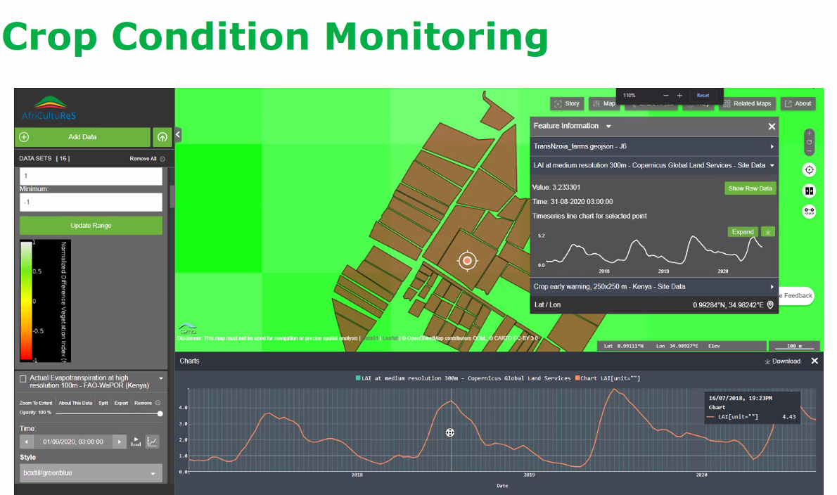
Earth observation for food security in Rwanda

The third AfriCultuReS hybrid workshop was held in Kigali on March 11.
This is what the experts said about the AfriCultuReS platform (https://africultures-platform.eu/):
the platform helps improve crop monitoring, it is rich in content and combines different types of data from a variety of sources in one platform, it is easily updatable and data access is also easy, it is user friendly, open source and supports the digital transformation of agriculture.
Points for improvement: the platform is not suitable for non-expert users (policy makers, farmers), the resolution is not high enough for some applications (for individual smallholder farmers, areas with a lot of mixed cropping), the good internet connection that is needed is not always available and data export is not easy.
The experts advised to make the platform available in the local language, to make integration with data and platforms of government agencies possible, to add other data needed to make Rwandan uses cases relevant, to add a search/query option and to provide training for local, non-expert users.
They considered the platform particularly useful for crop monitoring, crop index insurance, crop phenology, climate services, land and water monitoring and food security early warning.
Earth observation for food security in Niger
The AfriCultuReS platform (https://africultures-platform.eu/) was the main topic of discussion during the AfriCultuReS Niger workshop of March 3.
This is the opinion of the experts:
many services and products are offered, the design is user-friendly, the platform is easily accessible and multi-functional. A downside is that a good internet connection is needed, but not always available in Niger.
A French version was requested, instruction tutorials and videos are very much needed and the possibility to integrate your own data into the platform and to overlay different types of data would be very much appreciated. Special attention should be given to non-GIS and remote sensing experts as users. Specific requests related to more information about quantified biomass, soil fertility maps and a good link with transmission channels that are used to convey messages and warnings to farmers.
The fact that lots of data on different topics are available was considered very useful. Biomass monitoring, fire monitoring, water bodies monitoring, soil degradation and drought monitoring were mentioned as topics of interest for which the platform could be used.
Earth observation for food security in Mozambique
The AfriCultuReS workshop for Mozambique was held on February 25.
The experts who assessed the AfriCultuReS platform (see https://africultures-platform.eu/) liked
the easily accessible interface, the user-friendliness of the platform and that a lot of data are offered at low or no cost. A minus is that there is (still) no option to add your own data and that bad connectivity may slow down navigation and downloading data.
They advised to provide a translation into Portuguese and to provide training in the use of the platform for different target groups, such as policy makers, extension workers and farmers. An extension of use cases for Mozambique was requested that includes more crops and attention for rainfed agriculture. More specific topics were also mentioned, such as land degradation maps, very high resolution imagery for monitoring of dykes, assessment of hay production for livestock and development of mobile apps for farmers.
The easy access to high resolution images, the demarcation of different types of land use (forest, agriculture), provision of information on climate and many aspects related to agriculture and the availability of time series that allow identification of trends (deforestation, production, etc.) were considered especially useful.
Earth observation for food security in South Africa
The third AfriCultuReS workshop was held on Tuesday February 22 with special attention for the AfriCultuReS platform on Earth observation for food security: https://africultures-platform.eu/
Experts liked
the open source platform, the visualisation, the easy access and that the platform is a one stop shop for Earth observation dedicated to agriculture. The availability of time series with good frequency and the integration of different types of information are also strong points. The platform is considered a great enabler for capacity building.
Navigation was sometimes difficult and the resolution too coarse for specific applications. A user manual, demonstration videos and tutorials were recommended. The download functionality, webmap links and the legend description could be improved.
For rangeland health, which is the AfriCultuReS use case for South Africa, a layer indicating the browsing and grazing capacity could be added. All in all the availability of high resolution data for your own area of interest with already validated products was assessed as very positive.
Embedding Earth observation initiatives in localised contexts for financial sustainability – involving smallholder food producers and local governments
These are the main takeaways from the panel discussion of the GEO week side-event organised by the Geodata for Agriculture and Water Facility (G4AW – Netherlands Space Office), and the AfriCultuReS and TWIGA Horizon2020 projects, with presentations from Frank Annor, Lilian Benzid, Akua Benewaa and Mango Mbambi :

A recording of the whole event is available at https://www.youtube.com/watch?v=VYAE4q0ynrQ and you can find a compilation of the presentations here.
The right to water and food: digitalisation, informed decision-making, empowerment, inclusiveness & the rights-based approach
An important advantage of digitalisation and remote sensing in particular is that it facilitates informed decision-making, can serve as an instrument for empowerment (increased transparency) and supports inclusiveness. But how is this put into practice and take existing power relations into account?
Especially in the context of tackling poverty many factors play a role and often there are conflicts of interests (just look at history in general). In many cases investments of some sort are needed and politicians and administrators are very good at saying “we’ll look into it” very eloquently, which frequently leads to (indefinite) postponement.
An example from my own experience: As a young engineer I was involved in a protest march of indigenous people to the capital city claiming their right to drinkable water. As the recently elected president profiled himself as the president-of-the-poor there was no nice way to keep people out and the office of the vice-minister filled rapidly with poncho-clad representatives of the community. After a vivid discussion the vice-minister said that it was a complicated matter that needed more study. I intervened that we already had a technical design and substantial funding and that the only thing we needed from the government was about 20km of second-hand (note: not second-rate) steel tubes to cross a deep valley (which we knew the government had in store). Fortunately all this was already discussed with the technical people from the national water agency. Within five years the system was completed.
What did I learn from this?
1 A certain level of political will is required.
2 The community / communities concerned
need to be united behind the cause.
3 The solution needs to be clear, technologically
feasible and financially affordable.
For a long time I did not come across practical literature on this topic. But when doing a study on digitalisation for the Netherlands Ministry of Foreign Affairs I interviewed people from WWF and IUCN on an initiative called Shared Resources, Joint Solutions. They produced a small handbook on influencing. It has now disappeared from their website, although they have a lot of documents with examples of the rights-based approach. Therefore I present the main steps for action from the handbook here:
Ten steps to develop an effective influencing strategy:
1 Who are you? (Creating a manifesto of legitimacy,
which should determine whether, or not, power
holders will listen to your arguments and respect
your interests on the issue. This can be based on
e.g. mass mobilisation, expert knowledge or
personal relations).
2 What is the problem?
3 What policy has to change to solve the problem?
4 Who is the power holder of the policy change?
5 Where in the decision-making process are we?
6 Who are your friends (and not)?
(stakeholder (power) mapping)
7 What is your strategy to influence?
8 Make an activity plan.
9 Just do it! And monitor and learn from it.
10 Be flexible! Adjust your strategy to
new developments.
This leads to nine assignments to develop your influencing strategy:
* Who am I? Assignment #1: Write or draw a manifesto.
* What is the problem of the powerless? Assignment #2:
Formulate or draw the problem.
* What policy has to change to solve the problem?
Assignment #3: Formulate or draw the policy change.
* Who is the power holder of the policy change?
Assignment #4: Make a profile of the power holder.
* Where in the decision making process are we?
Assignment #5: Make a timeline of all the decisions
leading up to the policy change.
* Who are your friends (and not)?
Assignment #6: Build a partnership with allies.
* What is my strategy to influence? Assignment #7:
Work out an influencing strategy document.
* Make an Activity Plan? Assignment #8:
Make an activity plan and timeline.
* Do it! And monitor and learn from it! Assignment #9:
Do a reality check on the resources.
Indeed this is a recipe for lobbying, but the power dimensions that always play a role are addressed and there is a nice fit with the example I mentioned. We aim to take these lessons to heart in the development of services in the AfriCultuReS (http://www.africultures.eu) and TWIGA H2020 projects.
How do you make remote sensing data work for diverse small-scale farmers and pastoralists in diverse African contexts?
By Brittany Bunce and Maurice Beseng 15.07.2021

In the last two decades, there has been a growing appeal to use data derived from Earth Observation (EO) to support sustainable development policies in Africa, especially in the agricultural sector where there is a lack of reliable and timely information. EO data such as satellite remote sensing is seen as a powerful tool to modernise the monitoring and improvement of agriculture on the continent. Globally, there are many Earth Observation for Development (EO4D) initiatives, and an increasing number focusing on Africa that draw on remote sensing data to support decision-making in agricultural practices such as land cover/ land use mapping, crop/vegetation monitoring and famine early warning. An example is the “Enhancing food security in African AgriCultural systems with the support of REmote Sensing (AfriCultuReS)- a European Union-funded Horizon 2020 Project, which is developing an integrated agricultural monitoring and early warning system that brings remote sensing data together with crop and climate models to inform decision-making, with the ultimate aim of improving food security in Africa. The platform will provide seven bundled services related to climate, drought, land, livestock, crops, water and weather. It is hoped that a diverse set of end-users will be able to make use of the final platform, including small-scale farmers and pastoralists as the primary producers, as well as actors in the agribusiness, public, financial and academic sectors, across eight African partner countries.
While projects such as AfriCultuReS indicate the immense interest and ambition to leverage EO4D, the path from satellite images to sustainable agricultural policies or services in Africa is not straightforward. There are increasing concerns that current efforts to create EO4D applications for African agricultural development are largely built on foreign engineering designs rooted in the North, are financially unsustainable and fail to grapple with the key constraints faced by end users in Africa. Hence, despite the palpable excitement around the potential of using remote sensing data for agricultural development, there remains reason to be cautious and to take stock of some of the shortcomings and limitations of technical fixes to Africa’s complex agrarian system.
Emerging voices on EO4D for African agriculture advocate partnering with end-users in the co-creation of EO products through all stages of their design, implementation and evaluation. In this context, ‘capacity development’ approaches are being reconceptualized to accommodate the need to improve the ability of technical developers to create data and services that more closely serve the needs of end users. This is a welcomed move away from the paternalistic and rather simplistic focus on ‘building’ the capacity of end users to understand EO data, that may or may not be asking the right questions and hence might be unable to solve the key challenges end users face on the ground.

Figure: Smallholder goat and mango farm, Tzaneen, Limpopo Province, South Africa (Photo Credit: Brittany Bunce)
Clearly, solving food security challenges across various African socio-political contexts requires a methodology that allows remote sensing data to be embedded more closely within the complexity of diverse African agrarian systems. The concept of crowdsensing is being promoted to allow for the gathering of important georeferenced data by farmers and other end users, which can be processed through apps and shared in a collective manner through mobile devices. Importantly, the resulting platforms should integrate indigenous knowledge systems and be able to respond to the varied specificities of smallholder production. Remote sensing platforms should be able to take account of this world of complex social and ecological relations, otherwise purely top-down interventions are unlikely to be effective and worse, are at risk of endangering livelihoods or reinforcing local inequalities.
A question foremost in our mind is how end users without technical expertise in remote sensing and GIS can practically make use of a remote sensing platform to inform decision-making processes that improve the resilience and productivity of their farming systems. This concern has been echoed by partners and potential end users in engagements hosted in AfriCultuReS partner countries. It was suggested that in order to achieve impacts on food security it would be necessary to develop more accessible and user-friendly ways to package the data and to target a diversified set of communication methods to address some of the systemic technology barriers in different contexts e.g. the high cost of data in many African countries. Hence the challenge for developers and for capacity development approaches, is to now devise ways in which this data can be rendered practical and participatory and literally put to work in the field to aid farmers and pastoralists.
A lot of progress has already been made to develop off-line, open-source apps targeted at smallholders and pastoralists (m-Agri Services). However, smartphone access is patchy, and so this approach risks excluding some stakeholders. For this reason, current lessons emerging from AfriCultuReS partners suggest the need to make use of existing communication networks, such as agricultural extension systems, farmer associations or other context specific social networks, or making use of more broadly available communication networks such as local radio, SMS or social media. However, even if a user-friendly interface for an app can be produced and other accessible ways to package the data can be devised, some caveats still remain. Developing capacity among data developers to create the right resources and among end users to understand the data, does not in itself ensure effective decision-making that promotes food security. In other words, what needs to be done to ensure end users are able to interpret the data provided, and then use it to make very practical production and investment decisions on farms, rangelands, in markets and policy spaces?
To this end, participatory learning and decision-making processes can be integrated to bridge the gap between the platform that is developed and decisions that are made on the farm. There are a number of initiatives that are developing innovative ways to do this, for example, the Participatory Integrated Climate Services for Agriculture (PICSA) approach, which has been used across 20 countries. PICSA provides a step-by-step participatory decision-making framework that allows farmers to work together with trained facilitators (e.g. extension officers) to analyze climate data, together with farm-level data and links them to practical management approaches for specific farms or rangelands. Conceivably a similar approach could be implemented to ensure the seven bundled services provided by AfriCultuReS can be of practical use to farmers and pastoralists, although a precise approach is still being designed.
Figure: Smallholder cabbage plot, Vryheid, KwaZulu-Natal Province, South Africa (Photo Credit: Brittany Bunce)
The strength of a participatory approach like PICSA, is that farmers and pastoralists are in the driving seat and are being supported to make informed decisions, rather than being told what to do by extension workers, a radio announcement or a ‘SMS push notification’, that wouldn’t be able to understand the specificities of their individual farms and livelihood systems. This kind of participatory approach embraces the farm as an integrated social system, rather than just a composite of crops and livestock. The remedy posed to the complexity of EO data, however, is usually to simplify it through something like a ‘SMS push notification’. However, in the case of EO4D, simplicity may be a misfit for a complex challenge like food security and so grappling with complexity may be well worth the effort to ensure we find effective ways to support smallholders and pastoralists.
Link to original blog
Digital building blocks to go beyond pilots for food security
Most geodata applications for food security are still in the pilot stage. Geodata specialists tend to look to general digitalisation initiatives for inspiration. The idea is to learn from them as they started earlier and are supposedly more advanced. Is this true? Apparently not, if you look at the latest World Bank report on digital transformation of the agrifood system.

The report stresses the importance of reducing high transaction costs and information asymmetries and I like the distinction between on-farm and off-farm digital technologies and the emphasis on environmental sustainability. But if you want to know about the way forward, the focus is very much on the “what” and not on the “how”. It’s not that it isn’t a good report, it is just that I expected more. Evidently not only geodata applications, but also digitalisation initiatives in general still face many challenges.
Similarly, the demand for the creation of a new, digital ecosystem is accompanied by a plea for investment, but then the reader is left in the dark on how this will be achieved in developing countries. Granted, this is a very difficult issue, but I would have expected more insight, especially if you look at the positive picture that earlier reports sketch.
Which reports are these? I mention a few:
Key World Bank reports, one with the AfDB and the AU from 2014 on the transformational use of ICT in Africa and the esourcebook on ICT in Agriculture from 2017 give examples and indicate possible gains from digitalisation. This is why you would expect (or hope for) a structural embedding of digital solutions by 2021, but for many of the case studies it is difficult to find information on the current state-of-affairs and, assuming that successes will get publicity, this is disappointing.
Maybe I am just too impatient. Examples presented in more recent reports are easier to trace. Have a look at the Dalberg/CTA report on the digitalisation of agriculture, the GSMA agritech toolkit or the digital agriculture map GSMA 2020.
In summary, a comprehensive ecosystem for digitalisation in agriculture in developing countries seems still a long way off. For the “how” we have to go back to our pilots again (such as those of G4AW and NpM, now part of the Netherlands Advisory Board (NAB), and those presented in the reports above) and take it from there. Incremental, organic growth and system of systems approaches (such as GEOSS) can be effective.
The message to projects like AfriCultuReS and TWIGA and others is: focus on compatible and replicable building blocks that could fit in such an approach. These could then be used for a combination of applications in agriculture, climate adaptation and environmental sustainability.
Space-based services for smallholders: what have we learned?
The Geodata for Agriculture and Water Facility (G4AW) provided co-financing grants to 25 projects in Africa and Asia (23 targeted smallholder farmers and 2 targeted pastoralists). Each project’s objective within this Facility was to reach 100,000 farmers (or 50,000 pastoralists) and create a sustainable business model. The satellite-based services that were part of the portfolio offered were: weather information and forecasts, good agricultural practices, crop management and (index) insurance. For pastoralists information on (good quality) water and pasture was provided.

What have we learned? Some key findings:
There is no one-size-fits-all approach to creating successful digital agriculture advisory services. A key factor is how partnerships develop and adopt the right business model for service uptake. The presence of a large agro-business, insurer, bank or telecom company in the partnership creates favourable conditions for reaching food producers and bundling with other services.
For more info, including the recommendations, go to the publication
.png)
Geodata for AGTECH en FINTECH
There is quite some interest in geodata applications for inclusive finance for smallholder farmers. The idea is that financial institutions can make their operations more effective and more efficient. Geodata companies are looking for a combination of new markets and solving societal problems. Applications are credit scoring, assessment of repayment rate and time, geo-location of farms and plots, agricultural advice and risk management. The Platform for Inclusive Finance (NpM) and the Geodata for Agriculture and Water Facility (G4AW) funded a number of pilots.
The results of the pilots are very promising. However, there are a number of considerations to take into account:
Challenges encountered in the implementation of geodata applications were:
Two factors are especially important from an investor’s perspective:
The following technical, organisational and cross-cutting factors play a role in future developments:
 Universal and inclusive access to geospatial information for increased production and productivity in agriculture and water
There is a lot of attention for digitalisation for rural development (see for example the IT4D publication), however the sustainable increase of production and productivity in agriculture and water with the help of digitalisation has not reached scale yet. The current wisdom is that this is most likely, because most farmers in developing countries are smallholders, notoriously difficult to reach. Is this true? We’ll have a look.
But first a few starting remarks, going back to the title of this blog. Universal and inclusive access to geospatial information does not necessarily mean that this information is free. Inclusive is added, because people should be empowered to act on the information they get. Paradoxically, this strengthens the case for free, or at least affordable, information provision.
Returning to the subject: what makes the concept of digitalisation so attractive? There is a history of creating an enabling environment for digitalisation:
The first initiatives on digitalisation for agriculture were those by MNOs. A lot of these were evaluated in 2015 or 2016, but what happened after? The recently published GSMA AgriTech toolkit gives a good overview of best practices and examples. However, there is little information about value added services related to precision agriculture, only a statement that the business case is not clear (farm information is mostly used as a support measure for other services).This seems to confirm that indeed increasing production and productivity for smallholders is the most difficult part to address of the whole agricultural value chain.
But there are success stories. An example is the Garbal app for pastoralists, developed in the STAMP (Mali) and MODHEM (Burkina Faso) projects, supported by the G4AW Facility that promotes the use of satellite applications. Other G4AW success examples deal with weather (start of rainy season, forecasts, extremes) and/or agronomic advice for high-value crops (vegetables) or crops that cover relatively large areas (rice) and/or index insurance.
Indeed, as the GSMA AgriTech toolkit and a recent GrowAsia study indicate, establishing a sustainable business case for these apps takes quite some time. In addition to that, the technology has to work, the transmission channels need to be appropriate for the target group and data protection and platform ownership need to be arranged (to ensure long-term success, platform costs should be kept as low as possible). In addition, several initiatives indicated that the service provided should consist of information instead of advice, to respect the position and expertise of the farmer / pastoralist as decision maker and often a bundling of services is requested by the target group (to be more effective and to avoid duplication and fragmentation). This makes sense, as increasing production is not very useful, if access to markets is the main limiting factor.
Water management-related apps are maybe easier to market than agricultural apps for smallholders, if one aims at the government as the main client and partner. An example is the use of the HydroNET platform of the company Hydrologic deployed for the Ministry of Agriculture, Land Reform and Rural Development and water boards in South Africa. Usually it helps when these platforms are already developed for and functional in the home market.
This also applies to services that are offered to commercial farmers in developing countries. The € 10 – 13 / ha price (for a minimum of 25 ha) that the company IrriWatch charges for insight and advice on water consumption gives an indication of what to expect.
Other potential market opportunities are services for (local) government to facilitate decision making on food security, such as those developed by the AfriCultuReS project, and services based on the application (new) in situ sensors, such as those developed by the TWIGA project.
When looking at future perspectives, trends, opportunities and challenges, there are four types of providers (overlap is possible and the order does not give any indication of importance of priority) that can be distinguished as potential players in the market of services for agriculture and water:
Regardless of whoever will dominate the market, continuing support is needed to develop solutions that (also) cater to smallholders. Inclusiveness from start to end is a requirement for success, in the form of co-design and decision power for individual farmers and/or farmers’ organisations. Only if this condition is met, the promise of geospatial information of creating opportunities that change the context of doing business for and with smallholders will be fulfilled.
 Environmental accounting, on the dashboard or in the trunk?
Fortunately, the attention for environmental accounting and ecosystem accounting is growing. We need more systems for inclusive measurement, monitoring and evaluation.
There are many initiatives:
But they are not used as basis for decision making.
Just to give an example: in the Netherlands there is a great exercise on ecosystem accounting in the province of Limburg, but, as far as I know, this and the more general system of national environmental accounts are not the guiding principle for decision making. When it comes to decision making “traditional” economic arguments prevail. This leads to problems when policy measures for climate change get into conflict with cost-benefit calculations according to the narrow definition. Especially when this has been going on for decades, the consequences are severe. Look for example at the protests of Dutch farmers, who feel they are unfairly treated by the government with measures aimed at reducing the nitrogen surplus.
Of course, one could start a discussion about the metrics used in environmental accounting or ecosystem accounting and their validity. But the same applies to economic calculations, see for example Dan Brockington’s blog on farmers assets in Tanzania.
Why is it so difficult to integrate the two types of accounts? Perhaps because:
My own experience in agriculture is that environmental accounting and ecosystem accounting rank very low on priority lists of what should be addressed: increasing production and productivity and reducing (disaster) risk come first.
However, this does not mean that people do not care about sustainability, climate or environmental issues. It simply means that incentives should be changed and, as part of that process, the concept of environmental and ecosystem accounting should be promoted more.
Certification is certainly a step in the good direction. And an integration with data gathering and data analysis can help (look at reports like “Counting on the world to act”) Two H2020 projects, sponsored by the European Commission and dedicated to the improvement of data provision and analysis for food security, water and climate change in Africa, TWIGA and AfriCultuReS can make a small but important contribution to get environmental and ecosystem accounting from the trunk of the car to the dashboard!
Co-design in times of Corona
Home and office of the engineer
One of the few positive points of the Corona-crisis is that it provides an opportunity for reflection. For me this included looking at the design considerations I applied ages ago and the ones we use now. What are the differences and what is still valid? A lesson from the Corona-outbreak is not to take anything for granted. In developed countries the emphasis is very much on achieving maximum efficiency and effectiveness, in developing countries my design criteria focussed on maximum resilience. That means shifting from looking at “what can go right” to “what can go wrong”.
Nowadays we love to go for the new technical stuff, with buzzwords like big data, disruptive technology, machine learning, etc. In the process, we tend to forget the “what can go wrong”-side of things. Of course we talk of co-design, but in practice this is dealt with as a step in the process and then we go on with the technical things that make us so happy.
The danger is that this creates a mismatch between the “technical solution” and its successful long-term application. Not that there is anything wrong with technology, but things should be kept in perspective.


Co-design at work
Here are some design considerations from a long time ago that still apply, in my opinion, and are maybe forgotten in our desire to hit the ball out of the park. This effect is reinforced by the fact that most innovation funding is project-based and we therefore want to show quick results.
Cost reduction: This applies to the introduction of new technology that improves the current situation (e.g. platforms with services derived from big data), but in such a way that the solution is sustainable. Keeping the costs low, instead of counting on a high revenue – high cost scenario (that maximizes profit), reduces the risk of failure. This focus can even lead to additional design gains, where e.g. earthquake-resistant water tanks and acid groundwater-proof concrete well elements turn out to be cheaper than off-the-shelf solutions.

Disruptive technology in action
Anti-fragility: This term, coined by Nassim Taleb in his book Antifragile, deals not only with building in redundancy (look at the problems we have now with getting sufficient Corona-testing kits and intensive care beds and equipment in hospitals), but also with keeping the right purpose in mind. That means that wells should be equipped with buckets instead of handpumps, when you know that remote villages will never get visits from maintenance and repair teams. It also refers to the concept of granularity (thanks, Jack Dangermond of ESRI, for a discussion on this, already a long time ago). Design with granularity in mind reduces the risk that when one element malfunctions the whole system breaks down.
Long-term perspective: We should take the time (that we usually think we do not have) to design for the long-term and really involve the people concerned. They then become the owners of the solution, e.g. indigenous communities that get a “yes-we-can” spirit and go for installation of electricity after the drinking water system is completed. On the other hand, just as adjustments to the Corona-situation takes time for us, acceptance of new solutions also is a process that may take longer than anticipated. E.g. by involving everyone you avoid situations where the location of a planned well is “cursed”, because the local traditional well-diggers were not consulted.
And, of course, we are “human, all too human”: after a while we will forget what this Corona-thing was all about. But still, the crisis gives us a good opportunity to give co-design and innovation a new look.

Weather forecasting for agriculture in Africa, the business case?
Weather information is a priority for farmers, whether they use irrigation or not. It should be localised, timely and accurate enough, to make the information relevant at field level. In Africa, this is often not the case, although there are information providers, such as aWhere and Weather Impact, that are active on the continent.
There is a clear need for local meteo stations, not only for increasing the density of the meteorological observation network, but also for other parameters. To give an example: humidity is very important for to assess the conditions in which late blight disease in potatoes can occur (information derived from satellites only is not accurate enough). An organisation that aims at filling this gap is TAHMO. TAHMO has now 400 stations and plans to go to 20,000 meteo stations quickly.
But who pays for all this? Cooperation with national meteo agencies is a must, but the budget available is limited. Advertising, as with weather forecasting in developed countries (e.g. buienradar (shower radar) in the Netherlands) is not an option in Africa. In addition, these applications provide their information on the web, while in Africa transmission through SMS and IVR would be more appropriate and needs to be done in the local language(s).
An option is to provide weather forecasting in combination with other services. This could be an inclusive model, paid for in combination with other services in a package, such as agricultural advice. Another option is to make use of a loyalty model: offer weather forecasting in combination with fertiliser or pesticides (paid for by the supplier of these inputs). Weather forecasting can also be considered as a public good. It can then be offered in a service model, paid for by the government, such as the AgriCloud app (a cooperation between the South African Weather Service (SAWS), Hydrologic and others that provides very important and much needed information on the start of the rainy season.
See also “Get this weather app on your cell phone” by Nico Kroese. Here the government has to step in to perform a public function by reducing risk and increasing production and, of course, by paying for the service. And all this does not even take the context of climate change into account that makes weather forecasting even more important and relevant.
If anyone has examples of successful weather forecasting applications that have found a sustainable business model, you are very welcome to share them with me!

