AfriCultuReS is a European H2020 project


|

|
2019 |
|
| 11 - 23/12 |
3rd Conference on Geographic Information Systems |
|
|
|
| 11/12 |
"A change in the weather" |
|
|
|
| 02 - 13/12 |
UN Climate Change Conference COP 25 |
|
|
|
| 18 - 22/11 |
AfricaGIS |
|
|
|
| 04 - 09/11 |
GEO week |
|
|
|
| 8/10 |
"Paving the way for HorizonEurope |
|
|
|
| 04/10 |
Ground Truth 2.0 |
|
|
|
| 24 - 27/09 |
ISDE |
|
|
|
| 13 - 16/08
|
4th AfriGEO symposium and |
|
|
2020 |
|
| 26/11 | The AfriAlliance Triple Sensor Approach Virtual more information.. |
| 26/11 | Silk Road of Knowledge: Session 4 - Potentials of Digitalization for Increasing Sustainability in Agriculture Virtual more information.. |
| 23/11 | Earth Observation and Big Data for improved financial resilience Virtual more information.. |
| 19/11 | Influencing farmer behavioural change - relevant lessons for the new normal (AGRA) Virtual |
| 18/11 | ICTforAg 2020: Advancing resilience, nutrition, and agriculture-led growth in a digital world Virtual more information.. |
| 17 - 18/11 | Cultivate Africa: Galvanizing Partnerships for Promoting Resilient Agriculture and Food Systems in Africa in the Shadow of the Covid-19 Pandemic Virtual more information.. |
| 16 - 18/11 | Earth observation for water cycle science (ESA) Virtual more information... |
| 13/11 | IFAD/DEVEX Spotlight Climate – Financing for Farmers Virtual more information.. |
| 12/11 | Crop insurance: Data analytics, GIS and product design (GIZ, Making Finance Work For Africa) more information... |
| 12/11 | Digital Earth Africa - Continental Validation Webinar Virtual more information.. |
| 09/11 | Webinar – Monitoring croplands using remote sensing, ground data & machine learning algorithms Virtual more information.. |
| 05/11 | FAO Food Coalition - A Global Alliance to prevent the health crisis becoming a food crisis Virtual more information.. |
| 02 - 06/11 | GEO week 2020 more information... |
| 30/10 |
AIR Centre Networking Fridays - Thematic Special Session on African Marine & Coastal Operational Services: examples from around |
|
|
|
| 30/10 |
AfriAlliance final conference |
|
|
|
| 29/10 |
Nature & agriculture: Pathways to finance |
|
|
|
| 28 - 29/10 |
EO4AGRI final workshop |
|
|
|
| 20 - 22/10 |
FANRPAN Regional Multi-Stakeholder Dialogue: “Building Better and Resilient Agriculture and Food Systems" |
|
|
|
| 19 - 23/10 |
Digital dynamism for adaptive food systems |
|
|
|
| 13 - 15/10 |
AgMIP 8: Food systems, shocks and actions |
|
|
|
| 13 - 14/10 |
Conference: Is the UK on track to adapt to climate change? |
|
|
|
| 13/10 |
LEAP4FNSSA Boosting rural job creation and economic growth – Tapping the full potential of the Africa-EU research and innovation partnership in FNSSA |
|
|
|
| 05 - 09/10 |
EO for agriculture under pressure (ESA) |
|
|
|
| 30/09 |
Pathways to sustainability webinar |
|
|
|
| 24/09 |
A major African network for promotion |
|
|
|
| 17/09 |
Providing liquidity in agri value chains |
|
|
|
| 10/09 |
Enabling sustainable supply chains through |
|
|
|
| 07 - 08/09 |
2020 Americas Symposium (GEO) |
|
|
|
| 13/08 |
Redefining food safety: |
|
|
|
| 20/07 |
Agri All Africa: Building Back Better - |
|
|
|
| 08/07 |
Advancing the role of geospatial knowledge infrastructure in world economy, society and environment (Geospatial Media) |
|
|
|
| 03/07 |
COVID-19: Resisting now to build back better |
|
|
|
| 01/07 |
CEOS analysis ready data webinar |
| 23/06 | Drought early warning system (UNCCD) Virtual more information.. |
| 15 - 19/06 |
GEO Virtual Symposium more information.. |
| 12/06 | Farmers on the Frontline - Making digital agriculture work for small-scale farmers and rural transformation in a post-coronavirus world (IfAD) Virtual more information.. |
| 11/06 | Farmer-led irrigation development (Global Waters) Virtual more information.. |
| 10 + 24/06 08 + 22/07 |
FAO/AfDB Webinar series: Digitalization to transform agriculture in Africa and respond to COVID-19 Virtual more information.. |
| 09 - 11/06 | Web conference: Multidimensional resilience – smallholder producers managing risks Virtual more information.. |
| 08/06 |
EuroGEO workshop Virtual more information.. |
| 27/05 | Building the resilient supply chain (Cognizant) Virtual more information.. |
| 26/05 | Galileo EGNOS and Copernicus for agriculture (EO4AGRI) Virtual more information.. |
| 18/05 | Exploring potential adaptation options for policy and decision-makers: The Climate-ADAPT Catalogue (CMCC) Virtual more information.. |
| 08/05 | Farmers on the Frontline - Building resilience in a post-Coronavirus world (IFAD) Virtual more information.. |
| 07/05 | Service Facility for International Cooperation of the European Commission: Africa - Europe Innovation Partnership - Technology transfer in AfriCultuReS H2020 project Remote meeting-interview |
| 20 - 22/04
|
Virtual Training Workshop on Operational Modelling of Wheat Growth and Yield Estimate, organized by OSS - CNCT - ONAGRI – INRGREF Virtual more information.. |
|
|
|
|
25/03 |
Advancing Country-led Accountability for Performance in the Ag Sector: Africa’s CAADP Biennial Review (Agrilinks) Virtual more information.. |
|
|
|
|
03/03 |
Strategic Forum for International Cooperation (SFIC) Africa Task Force Strategic Workshop Brussels, Belgium more information.. |
|
|
|
|
24 - 27/02 |
UNECA - 6th Africa Regional Forum on Sustainable Development (ARFSD) “2020-2030: A Decade to Deliver a Transformed and Prosperous Africa through the 2030 Agenda and Agenda 2063 Victoria Falls, Zimbabwe more information.. |
2021 |
|
| 30/09 | Forecasting science for extreme weather & climate resilience across Africa Virtual more information.. |
| 21 - 23/09 | GEO Climate policy and finance workshop Virtual |
| 20 - 23/09 | EuroGEO workshop Virtual |
| 20 - 22/09 | GMES & Africa Regional workshop Virtual more information.. |
| 31/08 | Space, climate change and international cooperation (Secure World Foundation) Virtual more information.. |
| 23 - 26/08 | AmeriGEO Virtual more information.. |
| 17 - 19/08 | RCMRD international conference Virtual more information.. |
| 29/07 | A resilient food future: scaling digital climate advisory services for impact (WRI) Virtual more information.. |
| 28/07 | Southern Africa food security outlook briefing (FEWS NET) Virtual more information.. |
| 22/07 | Global risk financing technical talk: influence with technical stories (GRiF) Virtual more information.. |
| 11 - 16/07 | IGARSS Virtual more information.. |
| 08/07 | Establishing a baseline water risk assessment model in Ethiopia (WRI) Virtual more information.. |
| 07/07 | CreoDIAS Sen4CAP Virtual more information.. |
| 07/07 | GrowAsia directory showcase Virtual more information.. |
| 29/06 | GEO private sector meeting Virtual |
| 21 - 24/06 | GEO symposium Virtual more information.. |
| 17/06 | Scaling satellite-observed soil moisture index insurance in Africa (World Bank) Virtual more information.. |
| 16 - 17/06 | ExpandEO Fire forum, including Transforming Europe’s food system (EARSC) Virtual more information.. |
| 14/06 | ESA-EU SATCEN workshop on climate security Virtual more information.. |
| 10/06 | Africa-Europe space Earth observation high-level forum Virtual more information.. |
| 07 - 08/06 | African climate monitoring from space (EUMETSAT) Virtual more information.. |
| 03/06 | Soil information system for food security and sustainable intensification in Africa (FARA) Virtual more information.. |
| 26/05 | Agri-data research and innovation partnership (EC) Virtual |
| 25/05 | Harnessing the power of big data in cutting edge innovation (International Bioeconomy Forum) Virtual more information.. |
| 18 - 20/05 | Big data from space (ESA) Virtual more information.. |
| 05/05 | Space for water resources (Groundstation Space) Virtual |
| 28 - 29/04 | From best practices to practice – Earth observation for agro-insurance (ESA) Virtual more information.. |
| 28/04 | GEOGLoWS steering committee meeting Virtual |
| 20/04 | Research to innovation: Solutions to the climate crisis in Africa (University of Leeds, CGIAR, CCAFS) Virtual more information.. |
| 19 - 30/04 | EGU General Assembly 2021 Virtual more information.. |
| 14/04 | GEO meeting agriculture & land Virtual |
| 13/04 | Satellietdata en AI voor aarde Virtual more information.. |
| 31/03 | The role of satellite data and analytics in predicting the agricultural commodity chain and price trends (SpiceUp) Virtual more information.. |
| 30/03 | Evapotranspiration: Pitfalls to avoid and why it’s easier than you think (METER, Campbell) Virtual more information.. |
| 30/03 | IFAD Virtual Mission – Geodata for agtech and fintech (NpM Platform for Inclusive Finance and Netherlands Space Office) Virtual more information.. |
| 29/03 | WaPOR NICC web table talk Virtual more information.. |
| 22/03 | OECD toolkit for water policies & governance Virtual more information.. |
| 18/03 | Data intensive smart agrifood chains (DISAC) Virtual more information.. |
| 15/03 | Influence of COVID-19 on global agricultural insurance industry (AgroInsurance) Virtual more information.. |
| 09 - 10/03 | Copernicus and the Common Agricultural Policy Virtual more information.. |
| 09/03 | The future of farming: With satellite imagery, weather data, & deep learning (UP42) Virtual more information.. |
| 04 - 05/03 | Sen4CAP final workshop Virtual more information.. presentations |
| 26/02 | Digital information to tackle climate change and transform food systems (FAO) Virtual |
| 24/02 | Introduction to the GEO knowledge hub (GEO) Virtual more information... |
| 24/02 | Voices of Africa (AGRA) Virtual more information.. |
| 12/02 | Use of remote sensing data in agtech (6th grain) Virtual more information... |
| 28/01 | Roundtable on financing agricultural water (OECD-FAO) Virtual more information.. |
| 28/01 | Farming from space: Digital innovation for agriculture Virtual more information.. |
| 21/01 | Remote sensing and privacy (CAPIGI) Virtual more information.. |
| 13 - 18/01 | Climate-resilient food systems for Africa: From evidence to action (CGIAR, CCAFS) Virtual more information... part 1 part 2 part 3 |

Food Security Thematic Exploitation Platform
Juan Suárez presented the AfriCultuReS project during the 2nd workshop of the Food Security Thematic Exploitation Platform, FS-TEP, an initiative supported by ESA (held in Frascati, Italy, from March 5 -7).
Juan stressed the importance of involving all stakeholders: with its strong presence in Africa and participation of African partners, AfriCultuReS can cooperate with the FS-TEP partners in pilot cases and applications.
 Universal and inclusive access to geospatial information for increased production and productivity in agriculture and water
There is a lot of attention for digitalisation for rural development (see for example the IT4D publication), however the sustainable increase of production and productivity in agriculture and water with the help of digitalisation has not reached scale yet. The current wisdom is that this is most likely, because most farmers in developing countries are smallholders, notoriously difficult to reach. Is this true? We’ll have a look.
But first a few starting remarks, going back to the title of this blog. Universal and inclusive access to geospatial information does not necessarily mean that this information is free. Inclusive is added, because people should be empowered to act on the information they get. Paradoxically, this strengthens the case for free, or at least affordable, information provision.
Returning to the subject: what makes the concept of digitalisation so attractive? There is a history of creating an enabling environment for digitalisation:
The first initiatives on digitalisation for agriculture were those by MNOs. A lot of these were evaluated in 2015 or 2016, but what happened after? The recently published GSMA AgriTech toolkit gives a good overview of best practices and examples. However, there is little information about value added services related to precision agriculture, only a statement that the business case is not clear (farm information is mostly used as a support measure for other services).This seems to confirm that indeed increasing production and productivity for smallholders is the most difficult part to address of the whole agricultural value chain.
But there are success stories. An example is the Garbal app for pastoralists, developed in the STAMP (Mali) and MODHEM (Burkina Faso) projects, supported by the G4AW Facility that promotes the use of satellite applications. Other G4AW success examples deal with weather (start of rainy season, forecasts, extremes) and/or agronomic advice for high-value crops (vegetables) or crops that cover relatively large areas (rice) and/or index insurance.
Indeed, as the GSMA AgriTech toolkit and a recent GrowAsia study indicate, establishing a sustainable business case for these apps takes quite some time. In addition to that, the technology has to work, the transmission channels need to be appropriate for the target group and data protection and platform ownership need to be arranged (to ensure long-term success, platform costs should be kept as low as possible). In addition, several initiatives indicated that the service provided should consist of information instead of advice, to respect the position and expertise of the farmer / pastoralist as decision maker and often a bundling of services is requested by the target group (to be more effective and to avoid duplication and fragmentation). This makes sense, as increasing production is not very useful, if access to markets is the main limiting factor.
Water management-related apps are maybe easier to market than agricultural apps for smallholders, if one aims at the government as the main client and partner. An example is the use of the HydroNET platform of the company Hydrologic deployed for the Ministry of Agriculture, Land Reform and Rural Development and water boards in South Africa. Usually it helps when these platforms are already developed for and functional in the home market.
This also applies to services that are offered to commercial farmers in developing countries. The € 10 – 13 / ha price (for a minimum of 25 ha) that the company IrriWatch charges for insight and advice on water consumption gives an indication of what to expect.
Other potential market opportunities are services for (local) government to facilitate decision making on food security, such as those developed by the AfriCultuReS project, and services based on the application (new) in situ sensors, such as those developed by the TWIGA project.
When looking at future perspectives, trends, opportunities and challenges, there are four types of providers (overlap is possible and the order does not give any indication of importance of priority) that can be distinguished as potential players in the market of services for agriculture and water:
Regardless of whoever will dominate the market, continuing support is needed to develop solutions that (also) cater to smallholders. Inclusiveness from start to end is a requirement for success, in the form of co-design and decision power for individual farmers and/or farmers’ organisations. Only if this condition is met, the promise of geospatial information of creating opportunities that change the context of doing business for and with smallholders will be fulfilled.
 Environmental accounting, on the dashboard or in the trunk?
Fortunately, the attention for environmental accounting and ecosystem accounting is growing. We need more systems for inclusive measurement, monitoring and evaluation.
There are many initiatives:
But they are not used as basis for decision making.
Just to give an example: in the Netherlands there is a great exercise on ecosystem accounting in the province of Limburg, but, as far as I know, this and the more general system of national environmental accounts are not the guiding principle for decision making. When it comes to decision making “traditional” economic arguments prevail. This leads to problems when policy measures for climate change get into conflict with cost-benefit calculations according to the narrow definition. Especially when this has been going on for decades, the consequences are severe. Look for example at the protests of Dutch farmers, who feel they are unfairly treated by the government with measures aimed at reducing the nitrogen surplus.
Of course, one could start a discussion about the metrics used in environmental accounting or ecosystem accounting and their validity. But the same applies to economic calculations, see for example Dan Brockington’s blog on farmers assets in Tanzania.
Why is it so difficult to integrate the two types of accounts? Perhaps because:
My own experience in agriculture is that environmental accounting and ecosystem accounting rank very low on priority lists of what should be addressed: increasing production and productivity and reducing (disaster) risk come first.
However, this does not mean that people do not care about sustainability, climate or environmental issues. It simply means that incentives should be changed and, as part of that process, the concept of environmental and ecosystem accounting should be promoted more.
Certification is certainly a step in the good direction. And an integration with data gathering and data analysis can help (look at reports like “Counting on the world to act”) Two H2020 projects, sponsored by the European Commission and dedicated to the improvement of data provision and analysis for food security, water and climate change in Africa, TWIGA and AfriCultuReS can make a small but important contribution to get environmental and ecosystem accounting from the trunk of the car to the dashboard!
| Tidiane Ouattara | Head of the GMES & Africa Support Programme Unit | African Union Commission |
| Ian Jarvis | Director of GEO Global Agricultural Monitoring (GEOGLAM) | GEO |
| Edson Mpyisi | Principal Agricultural Economist, Agriculture and Agro-Industry Department | African Development Bank |
| Estherine Fotabong | Director, Programme Implementation and Coordination | NEPAD Agency |
| Rogerio Bonifacio | Head Geospatial Team at the UN World Food Programme, Food Security Analysis Service | WFP |
Enhancing Food Security in African AgriCultural Systems with the support of Remote Sensing.
| Project Number | : 774652 |
| Budget | : € 8.531.533 |
| Starting date | : 01/11/2017 |
| Duration | : 60 months |

AfriCultuReS presentation
Presentation of Juan Suarez on the future of AfriCultuReS.
Click on the picture below to see the presentation.
AfriCultuReS, for food security in Africa
AfriCultuReS supports AGRHYMET monthly bulletins
AGRHYMET produces each month a newsletter called AGRHYMET monthly bulletin, this bulletin is distributed through a mailing list of 4000 contacts. The bulletin is also distributed on CRA, CILSS and INSAH websites, and distributed to participants during the workshops.
During the rainy season, CRA organizes every 10 days a follow-up meeting of the agro-pastoral campaign, this meeting called a ten-day briefing is always sanctioned by a summary which is distributed internally and to certain partners, to allow these users to follow regularly the situation of the agro-pastoral campaign.
To ensure the visibility of donors, projects and technical partners who have contributed to the production of information, the logo of each one is added on the last page of the bulletin, as is the case with the AfriCultuReS project logo.
The bulletins are directed at technicians from the ministries of CILSS and ECOWAS member countries, NGO technicians and producer organizations, students and researchers.
Access the bulletins
The landscape of agricultural prediction is changing
By Chetan Deva, Samuel Bancroft and Andrew Challinor

Since de Wit first developed canopy scale models in the 1950’s, process-based crop models have been an important tool for predicting crop yields. One of the main challenges in fully realizing the potential of these models at regional scale has been lack of spatial information. To initialise these models, it is necessary to know what is being grown where. To evaluate these models, it is necessary to know what happened where.
In recent years, high resolution satellite data has helped with both issues. Images of vegetation have been used to develop powerful statistical learning algorithms capable of classifying crop type at the pixel level. In some cases, satellite data offers a simple answer to the crop classification problem. For example, researchers at Stanford have shown that it is possible to identify maize growing pixels from estimates of canopy height using LIDAR.
As the availability and resolution of time series satellite observations grows, inroads are also being made in developing crop yield data sets against which models can be tested. Using a uniquely large data set of yield observations, researchers have shown that it is possible to develop algorithms driven by satellite data that can estimate a useful share of variability in observed crop yields.
Aristotle University of Thessaloniki, GEOVISION
| Country | Greece |
| Website | www.geovision.web.auth.gr |
Organisation
GEOVISION is an interdisciplinary centre of AUTH established in 2014, integrating research groups from the Departments of Remote Sensing, Meteorology and Agricultural Engineering, working on disruptive market-ready solutions in the fields of Earth monitoring, GIS and production monitoring.
Main tasks
Work Package Leader for WP3
Task Leader for Tasks 1.2 , 3,1 and 3.4
Staff members
Thomas Alexandridis (leader)
Dimitrios Moshou (task leader)
Eleni Katragkou (task leader)
Ioannis Pitharoulis (task leader)
Afroditi Alexandra Tamouridou (participant)
Xanthoula Eirini Pantazi (participant)
Ines Cherif (participant)
Dimitris Kasampalis (participant)
George Ovakoglou (participant)
Ioannis Navrozidis (participant)
Dimitris Kasampalis (participant)
Stergios Kartsios (participant)
Maria Karypidou (participant)
Natasa Bougeli (participant)

Home and office of the engineer
Co-design in times of Corona
One of the few positive points of the Corona-crisis is that it provides an opportunity for reflection. For me this included looking at the design considerations I applied ages ago and the ones we use now. What are the differences and what is still valid?
A lesson from the Corona-outbreak is not to take anything for granted. In developed countries the emphasis is very much on achieving maximum efficiency and effectiveness, in developing countries my design criteria focussed on maximum resilience. That means shifting from looking at “what can go right” to “what can go wrong”.
Nowadays we love to go for the new technical stuff, with buzzwords like big data, disruptive technology, machine learning, etc. In the process, we tend to forget the “what can go wrong”-side of things. Of course we talk of co-design, but in practice this is dealt with as a step in the process and then we go on with the technical things that make us so happy.
The danger is that this creates a mismatch between the “technical solution” and its successful long-term application. Not that there is anything wrong with technology, but things should be kept in perspective.
From large to small or from small to large?
Lessons from the use of mobile apps and geodata apps for smallholder farmers

Satellite and geodata applications for smallholder agriculture are quite new, more general apps for smallholders that make use of mobile technology are around a bit longer. A number of these mobile initiatives have been evaluated (have a look at www.gsma.com) and it is interesting to look at the finding to see where geodata and mobile apps could complement each other, also with an eye on new application fields, such as (inclusive) finance.
Downscaling of MODIS LAI data
Presentation in IGARSS 2018
The International Geoscience and Remote Sensing Symposium is a premier event in remote sensing and provides an ideal forum for obtaining up-to-date information about the latest developments, exchanging ideas, identifying future trends and networking with the international geoscience and remote sensing community. This year it is taking place in Valencia, Spain, with the theme "Understanding and Forecasting the Dynamics of our Planet" (https://igarss2018.org/).
Partner AUTH is presenting "Spatial enhancement of MODIS Leaf Area Index (LAI) using regression analysis with Landsat Vegetation Index". The aim of this study was to enhance the spatial resolution of the MODIS LAI product using a downscaling model that combines Enhanced Vegetation Index and LAI images from the two satellites. The results show that it is possible to use this methodology to reliably estimate LAI at a 30m spatial resolution across various climates and ecosystems, thus supporting a food security early warning system.
The presentation is on Friday 27 July 2018, 9:30am.
Geodata for AGTECH and FINTECH
There is quite some interest in geodata applications for inclusive finance for smallholder farmers. The idea is that financial institutions can make their operations more effective and more efficient. Geodata companies are looking for a combination of new markets and solving societal problems.
Applications are credit scoring, assessment of repayment rate and time, geo-location of farms and plots, agricultural advice and risk management. The Platform for Inclusive Finance (NpM) and the Geodata for Agriculture and Water Facility (G4AW) funded a number of pilots.
Environmental accounting, on the dashboard or in the trunk?
Fortunately, the attention for environmental accounting and ecosystem accounting is growing. We need more systems for inclusive measurement, monitoring and evaluation.
There are many initiatives:
Universal and inclusive access to geospatial information for increased production and productivity
in agriculture and water

There is a lot of attention for digitalisation for rural development (see for example the IT4D publication), however the sustainable increase of production and productivity in agriculture and water with the help of digitalisation has not reached scale yet. The current wisdom is that this is most likely, because most farmers in developing countries are smallholders, notoriously difficult to reach. Is this true? We’ll have a look.
But first a few starting remarks, going back to the title of this blog. Universal and inclusive access to geospatial information does not necessarily mean that this information is free. Inclusive is added, because people should be empowered to act on the information they get. Paradoxically, this strengthens the case for free, or at least affordable, information provision.
Returning to the subject: what makes the concept of digitalisation so attractive? There is a history of creating an enabling environment for digitalisation:
 Space-based services for smallholders: what have we learned?
The Geodata for Agriculture and Water Facility (G4AW) provided co-financing grants to 25 projects in Africa and Asia (23 targeted smallholder farmers and 2 targeted pastoralists). Each project’s objective within this Facility was to reach 100,000 farmers (or 50,000 pastoralists) and create a sustainable business model. The satellite-based services that were part of the portfolio offered were: weather information and forecasts, good agricultural practices, crop management and (index) insurance. For pastoralists information on (good quality) water and pasture was provided.
Digital building blocks to go beyond pilots for food security
Most geodata applications for food security are still in the pilot stage. Geodata specialists tend to look to general digitalisation initiatives for inspiration. The idea is to learn from them as they started earlier and are supposedly more advanced. Is this true? Apparently not, if you look at the latest World Bank report on digital transformation of the agrifood system.

 The right to water and food:
digitalisation, informed decision-making, empowerment,
inclusiveness & the rights-based approach
An important advantage of digitalisation and remote sensing in particular is that it facilitates informed decision-making, can serve as an instrument for empowerment (increased transparency) and supports inclusiveness. But how is this put into practice and take existing power relations into account?
Especially in the context of tackling poverty many factors play a role and often there are conflicts of interests (just look at history in general). In many cases investments of some sort are needed and politicians and administrators are very good at saying “we’ll look into it” very eloquently, which frequently leads to (indefinite) postponement.
An example from my own experience: As a young engineer I was involved in a protest march of indigenous people to the capital city claiming their right to drinkable water. As the recently elected president profiled himself as the president-of-the-poor there was no nice way to keep people out and the office of the vice-minister filled rapidly with poncho-clad representatives of the community. After a vivid discussion the vice-minister said that it was a complicated matter that needed more study. I intervened that we already had a technical design and substantial funding and that the only thing we needed from the government was about 20km of second-hand (note: not second-rate) steel tubes to cross a deep valley (which we knew the government had in store). Fortunately all this was already discussed with the technical people from the national water agency. Within five years the system was completed.
What did I learn from this?
Brochures of services and marketing toolkit


Latest brochures of services
Digital building blocks to go beyond pilots for food security
Most geodata applications for food security are still in the pilot stage. Geodata specialists tend to look to general digitalisation initiatives for inspiration. The idea is to learn from them as they started earlier and are supposedly more advanced. Is this true? Apparently not, if you look at the latest World Bank report on digital transformation of the agrifood system.
The report stresses the importance of reducing high transaction costs and information asymmetries and I like the distinction between on-farm and off-farm digital technologies and the emphasis on environmental sustainability. But if you want to know about the way forward, the focus is very much on the “what” and not on the “how”. It’s not that it isn’t a good report, it is just that I expected more. Evidently not only geodata applications, but also digitalisation initiatives in general still face many challenges.
Similarly, the demand for the creation of a new, digital ecosystem is accompanied by a plea for investment, but then the reader is left in the dark on how this will be achieved in developing countries. Granted, this is a very difficult issue, but I would have expected more insight, especially if you look at the positive picture that earlier reports sketch.
Which reports are these? I mention a few:
Key World Bank reports, one with the AfDB and the AU from 2014 on the transformational use of ICT in Africa and the esourcebook on ICT in Agriculture from 2017 give examples and indicate possible gains from digitalisation. This is why you would expect (or hope for) a structural embedding of digital solutions by 2021, but for many of the case studies it is difficult to find information on the current state-of-affairs and, assuming that successes will get publicity, this is disappointing.
Maybe I am just too impatient. Examples presented in more recent reports are easier to trace. Have a look at the Dalberg/CTA report on the digitalisation of agriculture, the GSMA agritech toolkit or the digital agriculture map GSMA 2020.
In summary, a comprehensive ecosystem for digitalisation in agriculture in developing countries seems still a long way off. For the “how” we have to go back to our pilots again (such as those of G4AW and NpM, now part of the Netherlands Advisory Board (NAB), and those presented in the reports above) and take it from there. Incremental, organic growth and system of systems approaches (such as GEOSS) can be effective.
The message to projects like AfriCultuReS and TWIGA and others is: focus on compatible and replicable building blocks that could fit in such an approach. These could then be used for a combination of applications in agriculture, climate adaptation and environmental sustainability.
Centre for Remote Sensing and Geographic Information Services
| Country | Ghana |
| Website | cersgis.org |
Organisation
CERSGIS provides GIS and remote sensing services to public, private and non-governmental organizations and promotes the use of these technologies as decision, policy and research support tools for sustainable social and economic development.
Main tasks
Activity Leader within Task 1.2
Staff member
Foster Mensah (leader)
University of Rwanda - Center for Geographic Information Systems and Remote Sensing
| Country | Rwanda |
| Website | cgis.ur.ac.rw |
Organisation
CGIS-UR is a recognized, multi-disciplinary training and research centre of excellence in GIS and remote sensing technologies and applications and addresses issues such as societal and economic transformation and sustainable development in the domains of land administration, biodiversity conservation, sustainable urban planning, environment management and disaster risk management.
Main tasks
Contribution to several tasks and activities across different WPs
Staff members
Clarisse Kagoyire (leader)
Elias Nyandwi (participant)
Gaspard Rwanyiziri (participant)
Joseph Tuyishimire (participant)
Presentation Clarisse Kagoyire
At the webinar that was held on May 19 Clarisse Kagoyire gave a presentation on index-based crop insurance in Rwanda.
Click on the picture below to see the presentation.
Presentation Clarisse Kagoyire
At the webinar that was held on May 19 2022 Clarisse Kagoyire gave a presentation on index-based crop insurance in Rwanda.
Click on the picture below to see the presentation.
Climate services
 One of the most significant impacts of climate variability and climate change is the potential increase of food insecurity and malnutrition. Components of food security, such as yield and quality, are affected by climate-related issues. A deterioration of agro-climatic conditions also leads to price increases and the poor are hardest hit. It is therefore important to get insight into climatic trends to facilitate informed decision making on climate adaptation (and mitigation) for food security.
The AfriCultuReS climate service is part of a portfolio of services that can be combined for different applications. The other services are crop, drought, land, livestock, water and weather.
Click on the picture below to download the brochure.

Products
To see our climate services products, click on more...
Co-design in times of Corona
Home and office of the engineer
One of the few positive points of the Corona-crisis is that it provides an opportunity for reflection. For me this included looking at the design considerations I applied ages ago and the ones we use now. What are the differences and what is still valid? A lesson from the Corona-outbreak is not to take anything for granted. In developed countries the emphasis is very much on achieving maximum efficiency and effectiveness, in developing countries my design criteria focussed on maximum resilience. That means shifting from looking at “what can go right” to “what can go wrong”.
Nowadays we love to go for the new technical stuff, with buzzwords like big data, disruptive technology, machine learning, etc. In the process, we tend to forget the “what can go wrong”-side of things. Of course we talk of co-design, but in practice this is dealt with as a step in the process and then we go on with the technical things that make us so happy.
The danger is that this creates a mismatch between the “technical solution” and its successful long-term application. Not that there is anything wrong with technology, but things should be kept in perspective.


Co-design at work
Here are some design considerations from a long time ago that still apply, in my opinion, and are maybe forgotten in our desire to hit the ball out of the park. This effect is reinforced by the fact that most innovation funding is project-based and we therefore want to show quick results.
Cost reduction: This applies to the introduction of new technology that improves the current situation (e.g. platforms with services derived from big data), but in such a way that the solution is sustainable. Keeping the costs low, instead of counting on a high revenue – high cost scenario (that maximizes profit), reduces the risk of failure. This focus can even lead to additional design gains, where e.g. earthquake-resistant water tanks and acid groundwater-proof concrete well elements turn out to be cheaper than off-the-shelf solutions.

Disruptive technology in action
Anti-fragility: This term, coined by Nassim Taleb in his book Antifragile, deals not only with building in redundancy (look at the problems we have now with getting sufficient Corona-testing kits and intensive care beds and equipment in hospitals), but also with keeping the right purpose in mind. That means that wells should be equipped with buckets instead of handpumps, when you know that remote villages will never get visits from maintenance and repair teams. It also refers to the concept of granularity (thanks, Jack Dangermond of ESRI, for a discussion on this, already a long time ago). Design with granularity in mind reduces the risk that when one element malfunctions the whole system breaks down.
Long-term perspective: We should take the time (that we usually think we do not have) to design for the long-term and really involve the people concerned. They then become the owners of the solution, e.g. indigenous communities that get a “yes-we-can” spirit and go for installation of electricity after the drinking water system is completed. On the other hand, just as adjustments to the Corona-situation takes time for us, acceptance of new solutions also is a process that may take longer than anticipated. E.g. by involving everyone you avoid situations where the location of a planned well is “cursed”, because the local traditional well-diggers were not consulted.
And, of course, we are “human, all too human”: after a while we will forget what this Corona-thing was all about. But still, the crisis gives us a good opportunity to give co-design and innovation a new look.
 Juan Suarez, Business Development Manager at GMV, Spain
“Excited to coordinate such an exceptional group of people working together to meet the challenge of improving food security in Africa.” Mark Noort, Director at HCP international, the Netherlands
"The SBAM (Satellite Based Agricultural Monitoring) project, funded by Italian Space agency and covering Kenya, is very much in line with the objectives of AfriCultuReS!" (http://sbam.psm.uniroma1.it/)
Centre Régional AGRHYMET
| Country | Niger |
| Website | www.agrhymet.ne |
Organisation
The Centre Régional AGRHYMET (AGRHYMET Regional Centre) was created in 1974.
It is a specialized institution of the Permanent Interstate Committee for Drought Control in the Sahel (CILSS).
Main tasks
Activity Leader within Task 1.2
Staff members
Issa Garba (leader)
Amina Oumarou (participant)
Alio Agoumo (participant)
Binta Zalagou (participant)
Presentation Zakari Abdourahamane
At the follow-up webinar in French that was held on May 31, l’Afrique et les donnes spatiales Europeénnes, Zakari Abdourahamane gave a presentation on remote sensing for livestock management in Niger.
Click on the picture below to see the presentation.

Presentation Zakari Abdourahamane
At the follow-up webinar in French that was held on May 31, l’Afrique et les donnes spatiales Europeénnes, Zakari Abdourahamane gave a presentation on remote sensing for livestock management in Niger.
Click on the picture below to see the presentation.
Crop services
 Multi-scale historical and on-the-go crop assessment and monitoring coupled with yield forecasts provide the basis for evidence-based decision making on food security. Historical records facilitate a better understanding of the agricultural land use dynamics and the main factors affecting food production in a given area. Current and seasonal maps on crop land use and main crops grown, allow the precise identification, location and acreage of production areas. These maps can be subsequently combined with other products, such as crop condition maps, to produce enriched information. These inputs are used for planning and prioritisation of zonal interventions aiming at the improvement of the crop production conditions or to cope with food production shortages.
To make this process more effective and efficient, AfriCultuReS has developed a crop service. The crop service is part of a portfolio of services that can be combined for different applications. The other services are climate, drought, land, livestock, water and weather.
Click on the picture below to download the brochure.

Products
To see our crop services products, click on more...
Crop and crop condition mapping, suitability mapping in Kenya
 Click on the picture to download the PowerPoint presentation.
Crop early warning, PowerPoint presentation
 Click on the picture to download the PowerPoint presentation.
Earth Observation for Index-Based Agricultural Insurance in Rwanda
 Click on the picture to download the PowerPoint presentation.
Crop monitoring and yield forecasting
in Mozambique

Click on the picture to download the PowerPoint presentation.
Downscaling of MODIS LAI data
Presentation in IGARSS 2018
The International Geoscience and Remote Sensing Symposium is a premier event in remote sensing and provides an ideal forum for obtaining up-to-date information about the latest developments, exchanging ideas, identifying future trends and networking with the international geoscience and remote sensing community. This year it is taking place in Valencia, Spain, with the theme "Understanding and Forecasting the Dynamics of our Planet" (https://igarss2018.org/).
Partner AUTH is presenting "Spatial enhancement of MODIS Leaf Area Index (LAI) using regression analysis with Landsat Vegetation Index". The aim of this study was to enhance the spatial resolution of the MODIS LAI product using a downscaling model that combines Enhanced Vegetation Index and LAI images from the two satellites. The results show that it is possible to use this methodology to reliably estimate LAI at a 30m spatial resolution across various climates and ecosystems, thus supporting a food security early warning system.
The presentation is on Friday 27 July 2018, 9:30am.
We hope to see you there!


Opening by Dr. Franz Immler
Dr. Franz Immler opened the AfriCultuReS project on behalf of EASME and DG RTD Earth observation section
(Directorate-General for Research and Innovation).
He highlighted the main elements of the H2020 programme (the Research and Innovation programme of the European Union that runs from 2014 to 2020), with its three pillars of excellent science, industrial leadership and societal challenges, and the division of responsibilities with respect to supervision and support of implementation.
 His Excellency
Dr. Seleshi Bekele
The Honourable Minister indicated that food security and agriculture are among the most pressing priorities for Africa. Many Ethiopians depend on agriculture and it is the most important economic activity. Agriculture, however, faces a number of challenges: developmental, environmental and disasters, such as drought and erratic rainfall. A concerted effort of all stakeholders is needed to successfully achieve sustainable agricultural development.
His Excellency Dr. Seleshi Bekele
The Honourable Minister indicated that food security and agriculture are among the most pressing priorities for Africa. Many Ethiopians depend on agriculture and it is the most important economic activity. Agriculture, however, faces a number of challenges: developmental, environmental and disasters, such as drought and erratic rainfall. A concerted effort of all stakeholders is needed to successfully achieve sustainable agricultural development.

His Excellency
Dr. Seleshi Bekele
The Honourable Minister indicated that food security and agriculture are among the most pressing priorities for Africa. Many Ethiopians depend on agriculture and it is the most important economic activity. Agriculture, however, faces a number of challenges: developmental, environmental and disasters, such as drought and erratic rainfall. A concerted effort of all stakeholders is needed to successfully achieve sustainable agricultural development.
 The importance of food security
Dr. Ouattara outlined the importance of food security for Africa. The AfriCultuReS project is therefore very relevant.
The approach of AfriCultuReS is innovative, by involving the end-users and stakeholders. In the past 20 years the Earth observation community has worked too much in isolation.
DRAXIS Environmental Technologies
| Country | Greece |
| Website | draxis.gr |
Organisation
DRAXIS was founded in 2000 in Thessaloniki, focusing on environmental and agricultural IT applications and services.
Main tasks
Task Leader for Tasks 3.2 and 4.1
Staff members
Stelios Kotsopoulos (leader)
Stavros Tekes (task leader)
Drought services
 The drought service that is developed by AfriCultuReS tackles two main types of drought: meteorological and agricultural drought. Meteorological drought refers to a precipitation deficit over a certain period of time. Agricultural drought is defined by the availability of soil water to support crop and rangeland growth.
The impact of drought on food production depends on the intensity, duration and spatial coverage of drought. Decision making to cope with the effects of drought and aimed at mitigating its impacts, requires the assessment of past drought events, on-the-go monitoring and medium- to short-range early warning. This also contributes to the formulation of agricultural policy related to drought adaptation and resilience.
The drought service is part of a portfolio of services that can be combined for different applications. The other services are climate, crop, land, livestock, water and weather.
Click on the picture below to download the brochure.

Products
To see our drought services products, click on more...
AfriCultuReS Drought Services and Products for Africa
As is reflected by the different AfriCultuReS User Cases, drought is one of the main environmental threats that can dramatically affect food production due to its impact on soil degradation, agriculture and livestock, among others. To support decision-making, the AfriCultuReS’ Drought Services provide several products focusing at different time scales: monitoring seasonal forecast and climate change projections.
First, the current status is obtained based on the Combined Drouth Index (CDI) that is defined based on the following indices: Standardized Precipitation-Evapotranspiration Index (SPEI), Soil Water Condition Index (SWCI) and Vegetation Condition Index (VCI). These indices available through the AfriCultuReS platform reflect the precipitation and soil moisture deficits, and the drought impact on the vegetation condition.
 Figure 1: Warning level defined by the CDI corresponding to the second dekad (11th-20th) of July
Presentation on AfriCultuReS flood mapping product at EGU 2021

Cherif, I., Ovakoglou, G., Alexandridis, T. K., Mensah, F., and Garba, I.
Near real time high resolution mapping of flood extent in west African sites,
EGU General Assembly 2021, online, 19–30 Apr 2021, EGU21-15170
To the abstract of the presentation
Presentation on AfriCultuReS flood mapping product at EGU 2021
Cherif, I., Ovakoglou, G., Alexandridis, T. K., Mensah, F., and Garba, I.
Near real time high resolution mapping of flood extent in west African sites,
EGU General Assembly 2021, online, 19–30 Apr 2021, EGU21-15170
To the abstract of the presentation
Enhancing Food Security in Africa

Check out the latest version of the AfriCultuReS platform: http://africultures-platform.eu/en/
The platform will be continuously updated with new data and functionalities.

EU global action webinar

AfriCultuReS participated in the EU space data in action: supporting sustainable economic growth & a greener future for Africa webinar that was held on May 19 with presentations from Clarisse Kagoyire (on index-based crop insurance in Rwanda), Derick Ongeri / Vivianne Meta (on avocado production monitoring in Kenya) and Juan Suarez (on the future of AfriCultuReS).
A follow-up webinar in French was held on May 31: l’Afrique et les donnes spatiales Europeénnes, with presentations from Evence Zoungrana on the use of Copernicus data for agricultural monitoring in Tunisia and Zakari Abdourahamane on remote sensing for livestock management in Niger.
 AfriCultuReS in the EuroGEOSS launch
The AfriCultuReS project was presented as one of the example projects in the EuroGEOSS launch event that was organized in the week of the Group on Earth Observations (GEO), held in Washington DC from October 23 – 26, 2017.
Professor Pierre Defourny of the Université Catholique de Louvain in Belgium highlighted AfriCultuReS in his presentation on the EuroGEOSS agricultural pilot.
More information on EuroGEOSS
2021 |
|
| 30/09 | Forecasting science for extreme weather & climate resilience across Africa Virtual more information.. |
| 21 - 23/09 | GEO Climate policy and finance workshop Virtual |
| 20 - 23/09 | EuroGEO workshop Virtual |
| 20 - 22/09 | GMES & Africa Regional workshop Virtual more information.. |
| 31/08 | Space, climate change and international cooperation (Secure World Foundation) Virtual more information.. |
Field work
Each year extensive field work was carried out, also during the COVID period.
Summary reports of the field visits:
First project meeting
The AfriCultuReS project held its first project meeting at the premises of the coordinator, GMV, near Madrid, Spain, on April 19 and 20. Apart from progress during the first six months of the project and technical aspects, the discussions focussed on cross-cutting issues, such as climate change, user needs and gender. Now it is time to start the development of solutions that contribute to food security for the eight project regions in Africa, which will be tested first in the form of pilot projects. We will keep you posted on developments!


Fourth progress meeting
The fourth AfriCultuReS project meeting was held in Kigali, Rwanda on November 21 and 22, 2019, in conjunction with the AfricaGIS conference. Maize, wheat, potatoes and sorghum were selected as number one priority crops, while cassava, millet, rice and sugarcane where indicated as second priority crops. In addition to these crops, grasslands will be added for livestock and rangeland management.
Other topics for discussion were the AfriCultuReS methodology, the combination of satellite and in situ data, validation and calibration, data fusion and services federation, the AfriCultuReS IT platform, the business model and capacity development.
From large to small or from small to large?
Lessons from the use of mobile apps and geodata apps for smallholder farmers
Satellite and geodata applications for smallholder agriculture are quite new, more general apps for smallholders that make use of mobile technology are around a bit longer. A number of these mobile initiatives have been evaluated (have a look at www.gsma.com) and it is interesting to look at the finding to see where geodata and mobile apps could complement each other, also with an eye on new application fields, such as (inclusive) finance.
The approaches differ: apps that originate from mobile network operators (MNOs) tend to go for reaching large numbers of farmers quickly and then adjust the content, while the geodata service providers start small to get the tech aspects right and then go for scaling up.
This said, there are three areas where geodata could provide added value to mobile apps:
Conversely, geodata-based apps, such as those developed in the Geodata for Agriculture and Water (G4AW) Facility (https://g4aw.spaceoffice.nl/en/) can learn lessons in scaling up from mobile apps that already target large numbers of smallholders. Getting the tech aspects right is important, but reaching sufficient clients to make operations sustainable does not automatically follow from that.
Making use of power users (and/or authority figures as ambassadors), keeping the pricing model simple, making the service easy to operate for farmers, using local languages and metrics, taking illiteracy into account and taking care of long-term incentives for those in direct contact with the farmers are important findings from the evaluation of the impact of mobile apps that can be taken to heart in the further development of geodata-based apps.
In a fully operational phase the distinction between mobile apps and geodata apps will disappear. My expectation is that the two will be fully integrated, once the geodata apps get behind the experimental stage.
Expect this to happen pretty soon!
AfriCultuReS as GEO community activity
AfriCultuReS is accepted as a community activity in the 2020 – 2022 Work Programme of the Group on Earth Observations.
https://www.earthobservations.org/geoss_wp.php
This provides a very good opportunity to stimulate the development of concrete Earth observation-based solutions for food security in Africa through international cooperation.
GEO virtual symposium 21 - 24 June 2021
Have a look at the presentations of the AfriCultuReS use cases from Rwanda, Kenya, Ghana, Mozambique and South Africa here.
To watch the full recording of the AfriCultuReS session at the GEO symposium click here.

Embedding Earth observation initiatives in localised contexts for financial sustainability – involving smallholder food producers and local governments
These are the main takeaways from the panel discussion of the GEO week side-event organised by the Geodata for Agriculture and Water Facility (G4AW – Netherlands Space Office), and the AfriCultuReS and TWIGA Horizon2020 projects, with presentations from Frank Annor, Lilian Benzid, Akua Benewaa and Mango Mbambi :
- Co-design: involve key partners from the start;
- Make use of rural entrepreneurship;
- As we deal with data driven-solutions, use local service
providers;
- The best strategy for scaling depends very much on the
type of service offered;
- Licence-to-operate and (often) commitment from the
government is essential;
- Make use of reliable local actors and/or integrators for
local embedding (e.g. TAHMO with weather stations
at schools);
- Show impact of Earth observation and data-driven
solutions (cost-saving, time saving, improved
decision-making, etc.);
- Develop standard products / services that can be easily
replicated in other countries / regions (and make use of
a common platform).
A recording of the whole event is available at https://www.youtube.com/watch?v=VYAE4q0ynrQ and you can find a compilation of the presentations here.
Embedding Earth observation initiatives in localised contexts for financial sustainability – involving smallholder food producers and local governments
These are the main takeaways from the panel discussion of the GEO week side-event organised by the Geodata for Agriculture and Water Facility (G4AW – Netherlands Space Office), and the AfriCultuReS and TWIGA Horizon2020 projects, with presentations from Frank Annor, Lilian Benzid, Akua Benewaa and Mango Mbambi :
A recording of the whole event is available at https://www.youtube.com/watch?v=VYAE4q0ynrQ and you can find a compilation of the presentations here.
.png)
Geodata for AGTECH en FINTECH
There is quite some interest in geodata applications for inclusive finance for smallholder farmers. The idea is that financial institutions can make their operations more effective and more efficient. Geodata companies are looking for a combination of new markets and solving societal problems. Applications are credit scoring, assessment of repayment rate and time, geo-location of farms and plots, agricultural advice and risk management. The Platform for Inclusive Finance (NpM) and the Geodata for Agriculture and Water Facility (G4AW) funded a number of pilots.
The results of the pilots are very promising. However, there are a number of considerations to take into account:
Challenges encountered in the implementation of geodata applications were:
Two factors are especially important from an investor’s perspective:
The following technical, organisational and cross-cutting factors play a role in future developments:
Geo-Space Analytical Services
| Country | Ethiopia |
| Website | www.geosas.net |
Organisation
GeoSAS Ethiopia Consulting was founded in 2007 in Addis Ababa. GeoSAS Ethiopia Consulting has accumulated strong experience in the design, development and implementation of evidence based continental and national programmes for Sub-Saharan African (SSA) countries.
Main tasks
Task Leader for Task 2.2
Activity Leader within Task 1.2
Staff member
Woldeamlak Bewket (leader)
Teklemariam Haile (leader)
Teame Tewolde-Berhan (participant)
Asnake Mekuyiam (participant)

GMV Aerospace and Defense
| Country | Spain |
| Website | www.gmv.com |
Organisation
GMV is a privately owned technological business group with an international presence. GMV’s Remote Sensing Applications and Services (RSAS) Division is the developer of the proposed solutions in the project.
Main tasks
Coordination of the project
Work Package Leader for WP1 and WP5
Task Leader for Tasks 1.1 , 2.1 and 5.3
Staff members
Juan Suárez (coordinator)
Mar González (deputy coordinator)
Antonio Tabasco (project controller)
Marta Gómez Giménez (participant)
Jesús Ortuño (participant)
Presentation Juan Suarez
At the webinar that was held on May 19 Juan Suarez gave a presentation on the future of AfriCultuReS.
Click on the picture below to see the presentation.
Grant for AfriCultuReS
The H2020 AfriCultuReS project has been awarded by GEO (Group on Earth Observations) and AWS (Amazon Web Services) under the Amazon Sustainability Date Initiative with cloud services to provide Earth observation services in support of food security in Africa. The South African National Space Agency (SANSA) will coordinate the initiative titled “AfriCultuReS Decision Support System (ADSS) Community Version”.
Ground Truth week 2019
Mark Noort (HCP) participated in the closing panel of the Ground Truth 2.0 week in Delft, the Netherlands on October 4, 2019, and stressed the importance of making use of citizens’ observatories and the methodology developed and lessons learned of Ground Truth 2.0 in the AfriCultuReS project.
HCP international
| Country | the Netherlands |
| Website | www.hcpinternational.com |
Organisation
HCP International specializes in marketing of technology applications and capacity building for sustainable development.
Main tasks
Task Leader for Task 5.1
Staff member
Mark Noort (leader)
This project has received funding from the European Union's Horizon 2020 Research and Innovation Programme under Grant Agreement No. 774652
![]()
![]()
Europe’s eyes in the sky
“Europe’s eyes in the sky are helping to solve energy, land-use problems in Africa”
is the title of an article (by Aisling Irwin) in Horizon magazine, in which AfriCultuReS participants Juan Suárez, Issa Garba and Mark Noort give their views on achieving food security in Africa with the help of satellite data.
IN MEMORIAM ERICK KHAMALA
 With deep sadness we received the news of the sudden demise of our AfriCultuReS partner and friend Erick Khamala. Erick was not only a driving force between the AfriCultuReS project, but also a real ambassador for geospatial technology in Africa and beyond. We will miss his kindness, initiative, creativity, professionalism and great personality. Our thoughts are with Erick’s family and close friends. We are greatly thankful for what Erick has done for us. We know that Erick’s strong faith will help us in these difficult times.
Please find the obituary published by GMES and Africa below:
Posted: 11 Feb 2019 01:35 AM PST
The GMES and Africa Coordinator, Dr. Tidiane Ouattara, and the entire GMES and Africa team, regret to announce the untimely death of Mr. Erick Khamala, Managing Director of LocateIT, a private GIS and EO company based in Nairobi, Kenya. Mr. Khamala died on Thursday 7 February 2019 in Mauritius, where he was carrying out an EO private sector survey on behalf of the African Union Commission.
Mr. Khamala was a passionate advocate and promoter of EO in Africa. GMES and Africa extends heartfelt condolences to his family and the entire EO fraternity.
Mr. Khamala's family has started a fundraiser for his funeral.
A WhatsApp group has also been created by his family for those who want to pay tribute to him.
May his soul rest in peace
Index-based agricultural insurance

Click on this link to go to the blog on “Index-based agricultural insurance to address smallholder vulnerabilities to climate change: A look at ‘sustainability through design’” by Brittany Bunce (July 5, 2022).
Support to Irrigation in Tunisia
 Click on the picture to download the PowerPoint presentation.

 AfriCultuReS has started!
The kick-off meeting was held in Addis Ababa on November 23 and 24, 2017, organized jointly by GMV, the project coordinator, and GeoSAS, the host.
There were opening speeches of His Excellency Dr. Seleshi Bekele, Minister of Water, Irrigation and Electricity of Ethiopia, Dr. Franz Immler, Head of the sector Climate Action of the Executive Agency for SMEs of the European Commission, and Dr. Tidiane Outtara, Head of the GMES & Africa Support Programme Unit of the African Union.
AfriCultuReS has started!
The kick-off meeting was held in Addis Ababa on November 23 and 24, 2017, organized jointly by GMV, the project coordinator, and GeoSAS, the host.
There were opening speeches of His Excellency Dr. Seleshi Bekele, Minister of Water, Irrigation and Electricity of Ethiopia, Dr. Franz Immler, Head of the sector Climate Action of the Executive Agency for SMEs of the European Commission, and Dr. Tidiane Outtara, Head of the GMES & Africa Support Programme Unit of the African Union.
See also:
Supporting farmers in Africa with European Earth Observation technology
GMES and AFRICA participates in AfriCultuReS H2020 kick-off meeting
Land services
 Competition between different kinds of land use, such as agriculture, pastoralism and urban expansion, is a key challenge for sustainable land use planning. The increasing demand of space for urban and other non-food production activities relegates food production to less suitable areas. This leads to lower productivity of agricultural land. In addition, other factors, such land degradation and soil erosion or the occurrence of disasters, have negative impacts as well.
The enhancement of food production requires the continuing monitoring and assessment of these factors for improved and informed decision making for sustainable land use.
The AfriCultuReS land service is part of a portfolio of services that can be combined for different applications. The other services are climate, crop, drought, livestock, water and weather.
Click on the picture below to download the brochure.

Products
To see our land services products, click on more...
Make remote sensing data work
How do you make remote sensing data work for diverse small-scale farmers and pastoralists in diverse African contexts?
Here is the latest blog from Brittany Bunce and Maurice Beseng of the Sheffield International Institute for Development.
Livestock services
 Pastoralism is a vital part of the African economy. Almost 70% of Africa’s agricultural land is used to graze animals. Especially for small farmers, animals are a very valuable asset, providing dairy products to sell, pulling power for farm ploughs and transport for the family. Livestock and rangeland management requires the assessment and monitoring of (potential) grazing grounds in a timely and regular manner to support decision making and for planning of interventions to improve productive conditions.
The AfriCultuReS livestock service is part of a portfolio of services that can be combined for different applications. The other services are climate, crop, drought, land, water and weather.
Click on the picture below to download the brochure.

Products
To see our livestock services products, click on more...
LocateIT
| Country | Kenya |
| Website | www.locateit.co.ke |
Organisation
LocateIT Limited is a private company registered in Kenya in the year 2008. The company’s mission is to provide highly sophisticated yet simple location based Geo-ICT products and services that positively impact society.
Main tasks
Task Leader for Task 4.2
Activity Leader within Task 1.2
Staff members
Erick Khamala (leader†)
Vivianne Meta (leader)
Steve Omondi (participant)
Vance Udoto (participant)
Presentation Derick Ongeri and Vivianne Meta
At the webinar that was held on May 19 Derick Ongeri and Vivianne Meta gave a presentation on avocado production monitoring in Kenya.
Click on the picture below to see the presentation.

Presentation Derick Ongeri and Vivianne Meta
At the webinar that was held on May 19 2022 Derick Ongeri and Vivianne Meta gave a presentation on avocado production monitoring in Kenya.
Click on the picture below to see the presentation.
Crop type and land use maps
Crop type maps and land use maps were developed for the study areas in Tunisia, and also at the national level (plus a technical note).
Example of a crop type map:
For bigger maps contact louis.zoungrana@oss.org.tn
For more examples of the study area maps, a map at national level plus a technical note click on more...
The AfriCultuReS marketing toolkit on Earth observation for agriculture and food security
provides an overview of, and basic information on, Earth observation applications for agriculture and contextual information on agriculture and food security.
The marketing toolkit consists of a presentation and a literature reference list.
Presentation (PDF) click on the picture

Literature reference list (version August 2023)
(new references in red)
click for the literature reference list
Associated report on the Marketing Toolkit
This report serves also as user manual (click on the picture below)
Update Marketing Toolkit and literature reference list
Overview of experiences with digitalisation for agriculture: an update of the AfriCultuReS marketing toolkit and reference list
New are the examples with AfriCultuReS use cases and an overview of the services from the sister-project TWIGA (https://website.twiga-h2020.eu/).
Recent additions to the reference list are indicated in red font. All links to the literature have been checked (October 14, 2021).
Toolkit click on the picture

Literature reference list click (new references in red)

Workshops AfriCultuReS
In February and March 2022 workshops took place in South Africa, Mozambique, Niger, Rwanda, Kenya and Ghana.
Go to blogs

The Lab of Remote Sensing and GIS of the Faculty of Agriculture (http://labrsgis.web.auth.gr/) is a leading research and education Laboratory on Earth observation (EO) and geoinformatics for agronomic applications, including the broader sphere of agricultural activities and their impacts on the environment.
Key areas of research are:
Monitoring agricultural resources exploiting EO and land surface models (mapping agricultural crops, digital soil mapping, agricultural water use, precision farming);
Quantitative remote sensing (estimation of evapotranspiration, soil moisture, green biomass, leaf area index); and
Monitoring of the environmental impacts of agriculture (soil erosion, estimate downstream water quality and quantity).
The Department of Meteorology and Climatology (http://meteo.geo.auth.gr/) was founded in 1929 and its personnel have expertise in climatology, regional climate modelling, synoptic, dynamical, satellite and agricultural meteorology/climatology, weather and chemical weather forecasting and. It hosts a MSc Program in Meteorology Climatology and Atmospheric Environment and its permanent staff members are involved in a number of national and international projects.
The Agricultural Engineering Lab of the Faculty of Agriculture is active in the field of robotics, RFID and zigbee for robot localization and food traceability applications, robot task and motion planning, intelligent tracking and coordination for robotic systems. Other areas of research include intelligent control, intelligent techniques development (machine learning, neural networks, and self-organizing systems), data fusion and intelligent sensors.
The Centre for Remote Sensing and Geographic Information Services (CERSGIS) was established in 2000 as a company limited by guarantee by the University of Ghana and the Environmental Protection Agency (EPA) of Ghana.
GIS and remote sensing services
CERSGIS provides GIS and remote sensing services to public, private and non-governmental organizations and promotes the use of these technologies as decision, policy and research support tools for sustainable social and economic development. The Centre specialization is in remote sensing and GIS services for land and water resources appraisal and monitoring such as mapping flood hazards, desertification, agricultural development, land use/land cover changes, spatial modelling, vulnerability assessment and capacity building through education, research and training.
International and domestic
Since its establishment, the Centre has worked with prominent international and domestic institutions. Major clients include; FAO, UNDP, UNEP, EC, AfDB, WB, USAID, DFID-UK, GIZ-DE, Ghanaian Authorities: Ministries of Food and Agriculture; Rural Development; Environment; Science and Technology; Finance and Economic Planning, the Environmental Protection Agency and the National Disaster Management Organization.
The Centre for Geographic Information Systems and Remote Sensing-University of Rwanda (CGIS-UR) is a Research and Training Centre of the University of Rwanda, under the Ministry of Education.
Training and research centre
CGIS-UR promotes a spatially literate society by serving as a recognized, multi-disciplinary training and research centre of excellence in GIS and remote sensing technologies and applications. Through GIS and remote sensing, it addresses issues of local, national and regional importance such as societal and economic transformation and sustainable development in the domains of land administration, biodiversity conservation, sustainable urban planning, environment management and disaster risk management. Until now, CGIS-UR is the leading institution in Rwanda in the field of geo-information technology. The centre comprises permanent and affiliated researchers and technicians.
National and international projects
CGIS-UR successfully completed national and international projects:
Strengthening educational institutes in providing capacity building services for sustainable agricultural development in Rwanda (funded by NUFFIC, 2015 - 2021);
Spatial development framework of Rwanda in collaboration with UN, Human Settlements Program and University of Twente (funded by UN-Habitat, 2015 - 2016);
Integrated, Flood Modelling for Flood Risk analysis in Kigali City (funded by USAID through SERVIR-Eastern and Southern Africa Project operating under RCMRD, 2014 - 2015);
Updating of the national forest cover mapping using high resolution aerial photography (funded by MINIRENA/PAREF, 2012);
Healthy, environmental change and adaptive capacity: mapping, examining and anticipating future risks of water related vector-borne diseases in Eastern Africa (funded by the European Union through EU FP7-Healthy Futures, 2010 - 2014); Study on climate change and food security (under the Lake Victoria Research Initiative (VicRes), 2012 - 2015);
Providing quality education, research, consultancy and services in the field of geo-information science that meet labour market requirements and support the sustainable environmental and socio-economic development of Rwanda (NICHE/RWA/071, funded by NUFFIC, 2011 - 2015);
Development of a GIS decision support system for the coffee sector in Rwanda (SPREAD/USAID, funded 2007 - 2009);
Development of GIS based information system for malaria prevention in Rwanda for National Malaria Control Programme (project under the Ministry of Health, funded by the Belgium Technical Cooperation and Global Fund 2007 - 2008).
The Centre Régional AGRHYMET (AGRHYMET Regional Centre) was created in 1974. It is a specialized institution of the Permanent Interstate Committee for Drought Control in the Sahel (CILSS).
CLISS
CLISS is composed of thirteen member States countries (Burkina-Faso, Cape Verde, Chad, Guinea Bissau, Mali, Mauritania, Niger, Senegal and The Gambia). Actually, AGRHYMET is moving his expertise to the other countries of ECOWAS area (Republic of Guinea, Liberia, Sierra Leone, Ghana, Côte d’Ivoire, Benin, Togo and Nigeria). It is an interstate public institution with a legal status and financial autonomy. It has an international status and is based in Niamey, Niger.
The primary objectives of AGRHYMET are:
to contribute to achieving food security and increased agricultural production in the CILSS member States;
to improve natural resource management in the Sahel region by providing training and information to development stakeholders and partners in agro-ecology taken as a whole (agro-climatology, hydrology, crop protection, pastoralism…).
It is a regional institution specialized in the science and techniques applied to agricultural development, rural development and natural resource management.
Mission:
Training and consolidating previous knowledge transfer;
Capacity building of member States;
Meteorological and hydrological assistance (training, equipment and financial support);
Production and dissemination of information to various decision makers (national authorities, cooperation partners, NGOs and farmers);
Dissemination of relevant information on crop and environment to national & regional level.
DRAXIS was founded in 2000 in Thessaloniki, focusing on environmental and agricultural IT applications and services.
Innovative
DRAXIS provides innovative applications and services with respect to its customers. Its state-of-the-art and standards compliant technology solutions enable the company to deliver competitive solutions and customized services. The company’s mission is to cover the needs of all stakeholders in the environmental, food and agricultural spectrum. DRAXIS has long experience in Agricultural IT Platforms, from requirements to development and implementation and finally, management and maintenance. It has participated in a large number of European and national research projects focusing on agricultural IT technology with exceptional performance. DRAXIS leads, among others, the H2020 project “APOLLO” that is related to agriculture sector, focused on the development of farm management advisory services based on earth observation. DRAXIS portfolio includes more than 40 local and national authorities, and more than 150 private organisations.
Expertise
Environmental software;
Environmental consulting services;
Environmental impact assessment;
Agricultural IT Platforms;
Geographic information systems (GIS).
DRAXIS is a dynamic, credible and socially responsible SME, committed to providing qualitative services with respect to its customers. Excellent services and exceptional environmental performance are ensured by an applied and certified management system: ISO 9001:2008 (Quality Management), ISO 14001:2004 (Environmental Management).
GeoSAS Ethiopia Consulting was founded in 2007 in Addis Ababa. GeoSAS Ethiopia Consulting, has accumulated strong experience in the design, development and implementation of evidence base continental and national programmes for Sub-Saharan African (SSA) countries. In collaboration with NEPAD, the development arm of the Africa Union, GeoSAS has developed a flagship programme the “Gender, Climate Change and Agriculture Support Programme (GCCASP)” under the NEPAD CAADP process funded by NORAD. On the basis of this continental programme, GeoSAS was also commissioned to develop national GCCASP projects for implementation in 5 SSA countries, including: Cameroon, Ethiopia, Malawi, Niger and Rwanda.
Since its inception in 2007, GeoSAS Ethiopia has forged a number of partnerships, among which international geospatial technology leaders and national university-based research institutions engaged in development activities in Africa, particularly in Ethiopia. With a strong office in Addis Abeba, for over a decade, GeoSAS had the opportunity to forge relationships with government development decision makers at the Federal, Regional State and Woreda (district) levels all over Ethiopia, with support offices in Bahir Dar and Mikelle, capital cities of the Regional States of Amara and Tigray respectively. In fact, both of these regional states benefit from AfriCultuReS.
GeoSAS UK
At the international level, GeoSAS Ethiopia established a sister company GeoSAS UK to catalyse the introduction of innovation, technology and collaborative partnerships in the UK and Europe for the support of development efforts in SSA countries towards improving investment in development activities, including in the harnessing of satellite-derived climate information for agri-business. In this area GeoSAS has partnerships with major technology leaders, including ESRI, and climate related evidence base developers, such as VITO of Belgium and Catapult UK. Currently, GeoSAS is collaborating with NEPAD to create a continental/regional Geospatial Platform for Africa in partnership with key international technology leaders.
Expertise
GeoSAS expertise and experience in development include: climate-related and evidence-based programme development and design, project management, and monitoring and evaluation. In addition to its core staff, engaged in business development, project operations management and M&E, GeoSAS is associated with high level professionals based in universities, independent consultants, and retired development practitioners with a wealth of knowledge and experience in the development challenges in developing countries.
Key role
Political key role: GeoSAS has a very good relationship with the key stakeholder, the Ministry of Agriculture and Natural Resources (MoANR), which is also involved in related disaster management issues, including drought.
HCP international is a micro-enterprise, located in Amsterdam, the Netherlands, and founded in 2012.
Marketing of EO
The aim of HCP international is to support sustainable development, with special emphasis on the application of innovative technologies, such as earth observation. HCP international achieves this by providing added value to customers through services in the field of marketing, acquisition, management and consulting.
HCP international specialises in topics related to earth observation, geo-information, agriculture, environmental management, water resources management, water supply and sanitation, disaster risk management, and climate action.
LocateIT Limited is a private company registered in Kenya in the year 2008. The company’s mission is to provide highly sophisticated yet simple location based Geo-ICT products and services that positively impact society. The company’s vision is to be a premier company that transforms communities in Africa through the provision of innovative Geo-ICT solutions.
Geo-ICT
LocateIT (www.locateit.co.ke) is a leading Geo-ICT company in Kenya, offering location-based products and services, pillared on ultra-modern space science and technologies / remote sensing / Earth observation, geographic information systems (GIS), airborne sensors, and geo-apps.
Very specifically, LocateIT offers the following:
Earth observation products and services;
GIS products and services;
Positioning and navigation products and services;
Integrated geo-ICT solutions;
Environmental and developmental applications that include climate change, REDD+, land degradation, suitability modelling for socio-economic planning and development, land use / land cover change mapping and prediction, early warning systems for food security and disasters, and monitoring and evaluation services.
OSS is a Tunis-based international, intergovernmental organization established in 1992.
OSS members include 25 African countries, seven non-regional countries, thirteen organizations (including sub-regional organizations representing West Africa, East Africa and North Africa), and a non-governmental organization. From its creation, OSS recognizes the importance of environmental monitoring and natural resource management, fields where the organization has acquired progress, with a focus on land and water.
Sahara-Sahel region
The organization operates in Africa’s Sahara-Sahel region. Key themes in the organization’s work are aligned with the challenges facing this vulnerable region: land degradation, desertification, drought and the adverse impacts of climate change on ecosystems and populations. The organization was accredited as an Implementing Entity for the Adaptation Fund in July 2013 and for the Green Climate Fund in 2017.
Support
The OSS aims to support regional member countries’ efforts in the fields of natural resource management and sustainable development that address themes within the scope of the organization’s mission:
Environmental monitoring;
Joint management of transboundary aquifers;
Support to the implementation of the Multilateral Environmental Agreements;
Disaster-Risk Reduction;
Integrated Water Resources Management (IWRM): modelling and study of linkages between aquifers and surface water;
Study of the socio-economic dimensions of water demand;
Climate change adaptation and resilience;
Transition to the Green Economy.
The South African National Space Agency (SANSA) is South Africa’s government body mandated by the SANSA Act, 36 of 2008. The mandate of SANSA is to coordinate and integrate space science and technology programmes, conduct long-term planning and implementation of space-related innovations in South Africa, and ensuring the supply of cost-effective space-based EO data and products to support South Africa’s policy, decision-making, economic growth and sustainable development. The Earth Observation focus area of SANSA thrusts to coordinate South Africa’s Earth observation activities. The main objectives are to collect, assimilate and disseminate earth observation data to support South Africa’s policy, decision-making and sustainable economic growth in the country.
EO services
SANSA’s impact is in providing amongst others, essential EO services to support EO research and development, as well as human capital development and science advancement activities. Through its research and application development activities, SANSA provides value added services to both state-owned departments, the private sector and other SME companies to establish the use of EO technologies in developing products and services, to better understand environmental risk resulting from mining, urbanisation, agriculture, etc. Key stakeholders include the South African Government departments and multinationals.
Through its mandate, SANSA has established several memoranda of understanding with both national (including institutions of higher learning) and international (including the JRC, the UK Space Agency, JICA/JAXA and DLR) collaborators to foster cooperation in space-related studies. SANSA is part of the Group on Earth observations (GEO) and through the South African Earth Observation Strategy (SAEOS) participates in Global Earth Observation System of Systems (GEOSS).
The EO Directorate of SANSA is currently providing Higher Education Institutions in South Africa with geospatial resources for student training through its Fundisa Disk Programme (FDP) which promotes the use of spatial information at tertiary level. Furthermore, through the MoU between SANSA and the JRC, the two institutions are collaborating to further develop and implement a National Human Settlements products and services for South Africa on an annual basis since 2012.
Cropwatch
Recently, with funding from the International Partnerships in Space Programme (IPSP) administered by the UK Space Agency, SANSA has developed a set of crop/vegetation monitoring tools called CropWatch for South Africa in partnership with Airbus Defence and Space Company in the UK. The CropWatch project hopes to stimulate both economic and societal benefits in South Africa (and indeed across southern Africa). The main goal was to develop and demonstrate a set of crop stress assessment tools that use satellite derived biophysical parameters (including fraction of vegetation or soil cover, LAI, FAPAR, leaf chlorophyll content and several vegetation indices) and agronomical information to optimise the monitoring of field crop areas in both irrigated and dryland production systems in South Africa.
The SANSA EO and Space Operation directorates also maintain daily direct reception and/or acquisitions of contracted Earth observation data over the Southern African region and support an extensive archive data dating back as far as 1980. Remote sensing scientists and application developers at SANSA EO have experience in research on automation of image processing and value-added product development, e.g. processing imagery to develop annual national mosaic from high resolution imagery for mapping the built environment including human settlements, general LC/LU mapping, extraction of agricultural croplands and associated field crop boundary feature extraction, etc.
The Sapienza University of Rome, is a collegiate research university located in Rome, Italy. Formally known as Università degli Studi di Roma "La Sapienza", it is the largest European university by enrolments and one of the oldest in history, founded in 1303.
School of Aerospace Engineering
The University of Rome 'La Sapienza' contributes to AfriCultuReS through the School of Aerospace Engineering (SIA) which is a Faculty funded in 1926 as School of Aeronautics Engineering and in 1961 became School of Aerospace Engineering. EOSIAL (Earth Observation Satellite Images Applications Lab) is a laboratory of the School devoted to developing applications, based on the exploitation of satellite images. The researchers group has been involved in many national and international projects (FP6, FP7, ECHO, ESA, INTERREG) concerning Earth Observation satellite applications for security, environmental monitoring, natural and man-made hazards.
Research
Experience includes teaching aerospace systems for remote sensing since 1998 and management (of about 15 years) of the Equatorial Remote Sensing station of the University of Rome in Kenya (Malindi). In particular, in the remote sensing field, the following research activities were carried out at SIA:
Monitoring of sea and internal water pollution phenomena (using AVHRR and SeaWiFS images, MERIS and ETM/TM);
Monitoring of human activity impact on coast erosion phenomena;
Satellite based accurate Land and Sea surface temperature estimate using an algorithm developed by SIA;
Desertification analysis;
Real time wild fire detection and monitoring based on geostationary images;
Automatic detection of given objects on satellite images;
Population monitoring;
National border monitoring;
Monitoring of equatorial atmosphere and atmospheric aerosols estimate;
Agricultural area monitoring and productivity estimate (L8, Sentinel-1, 2, Cosmo SkyMed, ALOS, etc.);
Satellite based detection of oil spill.
Implementation of automatic processing chain of satellite imagery devoted to environmental monitoring.
SMHI is a government agency with some 670 employees under the Swedish Ministry of Environment and Energy.
Decision support
SMHI runs both governmental services and commercial businesses. SMHI is providing decision support to a broad range of end-users, based on meteorology, hydrology, oceanography and climate information. SMHI is responsible for national monitoring and modelling in these fields, data archives and refinement of information for societal needs. On behalf of the government SMHI runs a national knowledge centre for adaptation to climate change.
Customized products and services
SMHI has a long tradition in developing customized products and services, as well as 24/7 production of forecasts with early warnings, and operates the dissemination of flood alerts to other EU member states in the EFAS system for EU Copernicus. It has a strong R&D focus with 110 full time scientists. SMHI is active in many GEOSS, Copernicus and ESA projects. SMHI is representing Sweden in relevant international organizations, e.g. ECMWF, WMO, EUMETSAT and IPCC.
The institute is involved in many national and international projects including those under FP7, H2020 and Copernicus. SMHI hosts the International Project Office for the WCRP Coordinate Regional climate Downscaling Experiment (CORDEX). The SMHI management system has been certified under the quality standards ISO 9001 and ISO 14001.
Universidad de Cantabria is a modern public institution, whose main purpose is to contribute to social progress through teaching and scientific excellence. It consists of around 1,600 researchers and 13,500 students (out of which 653 are PhD students), 3 research centres (joint initiatives with the Spanish Research Council CSIC), 4 associated research institutes, and 157 R&D groups from 32 departments. Moreover, UC is one of the 9 Spanish universities selected in the “Campus of International Excellence” Programme, promoted in 2009 by the Spanish Government.
UC is equipped with a modern infrastructure for data and IT management, logistics and general services. UC participated in 49 FP7 projects and is currently managing around 3 Million € in new H2020 projects every year. In addition, UC actively participates and coordinates 22 projects in other European funding schemes, such as LIFE+ (3), INTERREG (5), INFRAVATION (2) and RFCS (3). Regarding the present proposal, UC has leading research groups at European and International level in environmental sciences, including climate science (the UC Meteorology Group). Most of these groups are involved in sustainable development policies in collaboration with administrations of different regions in Spain.
UC Meteorology Group
The UC Meteorology Group is formed by 15 researchers and conducts research on various topics related to regional climate modelling (including dynamical and statistical downscaling methods) and information technologies applied to data and metadata processing (including web portals and services for data access and post-processing). In particular, the group specializes in data/metadata management, statistical and dynamical (WRF) downscaling and applications in different impact sectors (tourism, forest fires, health, critical infrastructures, energy). UC-MG is currently involved in several EU-funded projects, such as IS-ENES2, EUPORIAS, SPECS and INTACT and is actively involved in international initiatives, such as CORDEX, VALUE and IS-ENES. It is also involved in the COPERNICUS C3S tender QA4Seas for seasonal forecast evaluation, responsible for the task related to bias corrected and downscaled products. The group has also an agreement with FAO-ONU to provide tools, consulting and capacity development services for different food security initiatives developed worldwide. In the framework of these activities, the group has developed public user tools for accessing climate information.
Some of the UC-MG researchers are employees of the Spanish National Research Council (CSIC) at Instituto de Física de Cantabria (IFCA, mixed research institute from University of Cantabria and CSIC). Therefore, CSIC acts as a third party in this Project though Instituto de Física de Cantabria (IFCA).
The Eduardo Mondlane University (UEM) is a national public institution, the oldest institution of higher education in Mozambique. Currently it counts 37,000 undergraduate and 3,000 post-graduates students. It has 11 faculties and 6 schools.
Research in agronomy
The UEM team has worked in research projects related with agronomy for more than 15 years which resulted in a build-up of local knowledge on soil use and land cover, plant growth, agriculture practices and assessment of the drivers of deforestation and forest degradation in Mozambique. These works include habitat mapping in Mozambique funded by USAID/WWF and studies related with soil, land use, and pasture biomass that were financed by FAO.
This University has long collaborated with the Ministry of Agriculture, which will be the user of the integrated agricultural monitoring and early warning system that will be generated by AfriCultuReS in Mozambique.
UNIVLEEDS is one of the largest universities in the UK with over 32,000 full-time students, 7,500 staff.
Climate related research
The University of Leeds has more than 200 academic staff working on climate related research with £100m in research income and 40 papers published in Nature and Science between 2010 and 2015. Five lead authors for the IPCC Fifth Assessment Report (AR5) came from Leeds, which is one of very few worldwide institutions with leaders on all four AR5 reports. Research on the relationships between climate, agriculture, land use and food security at Leeds is significant: £3.66M between 2010 and 2015, involving 24 academics. A range of funders support this work, e.g. NERC, BBSRC, ESRC, EU, UNDP, DEFRA, Met Office and the CGIAR. Leeds has received considerable research council and other investment (over £20 million) to host cross-cutting centres such as the NERC NCAS and the ESRC Centre for Climate Change and Economic Policy (CCCEP) (with LSE).
The Priestley International Centre for Climate, established in 2016, is a major investment (£6.82 m over 5 years) by the University of Leeds to grow interdisciplinary research to underpin robust and timely climate solutions. The Priestley Centre aims to promote interdisciplinary research of the highest standard on climate change and its impact on nature and society.
School of Earth and Environment
The School of Earth and Environment (SEE) at Leeds is a large school with over 70 academic staff, 35 support staff and 65 Postdoctoral Research Fellows and Associates. SEE is an internationally recognised centre for research and teaching in earth and environmental system science and social science. SEE houses both the Sustainability Research Institute and the Institute for Climate and Atmospheric Science (ICAS). Both SRI and ICAS conduct world-class research on climate change and its impacts, from social and natural science perspectives, respectively.
Leeds works collaboratively with the CGIAR Programme on Climate Change, Agriculture and Food Security (CCAFS), which conducts research that is highly aligned with Post-Plus. The CGIAR is a global agriculture research partnership for a food secure future. Its science is carried out by the 15 research centers who are members of the CGIAR in collaboration with hundreds of partner organizations. CCAFS is collaboration across all 15 CGIAR research centres, with funding to date in excess of $200M.
Future Climate For Africa
SEE also gains significant funding for Africa-focussed research, including three major collaborative programmes of research under the Future Climate For Africa (FCFA) programme. The ultimate goal of FCFA is to reduce disruption and damage from climate change and to safeguard economic development and poverty eradication efforts over the long-term. In this way, FCFA aims to make new African infrastructure and urban and rural plans and investments more climate-resilient.
The University of Sheffield (USFD) is ranked in the top 100 universities in the World and is a member of the Russell Group of leading UK research institutes. Since 2007, Sheffield has participated in 353 EU projects, was part of 695 collaborations in 38 countries and was awarded 35 European Research Council grants. The university has a strong commitment to building research capability across Europe and collaboration at the international scale. International Development and Food Security are grand challenges in which USFD has recently invested.
Sheffield Institute for International Development (SIID)
A flagship interdisciplinary research centre with expertise drawn across the University. Specialist themes include natural resources and rural livelihoods, and data, digital technology and innovation. Funding for International Development research to the University from external sources in the last 18 months exceeds £3 million, building on an investment by the University of nearly £800,000. SIID’s partnerships overseas and particularly in African contexts are a particularly strong element of its work relevant to this proposal.
The Plant Production and Protection (P3) programme
A translational centre encompassing the breadth of soil and plant science expertise across the biological sciences. Over the last three years it has received over €7 million in university investment to facilitate collaboration with industry (agri-tech and a wide range of other commercial partners), through the refurbishment of facilities (climate-controlled environment centres, genomic, proteomic and imaging equipment) , pump priming funds and new staff appointments. P3 capitalises on our unparalleled ability to work across biological scales, from genome to the global atmosphere.
Sheffield Sustainable Food Futures (SheFF) group
Tackles global food security through integrated interdisciplinary investigations of agri-food systems, namely through the promotion of the social and health sciences within the food debate. Working with P3, this network explores interdisciplinary research avenues to ensure solutions to food security are rigorously considered from a social science perspective, leading to practical implementation at the level of government policy.
The Grantham Centre for Sustainable Futures
Focuses on the creation of knowledge and connection to policy debates on how to build a fairer world and save natural resources for future generations. The Centre encompasses early career researchers and staff and is funded through a donation made by the Grantham Foundation for the Protection of the Environment.
These institution initiatives are also embedded in a northern food research programme “N8 AgriFood Resilience”, which is a €19 million project funded by the UK government, connecting the eight most research intensive universities in the north of England (N8), including Sheffield.
Observatoire du Sahara et du Sahel
| Country | Sahara and Sahel region |
| Website | www.oss-online.org |
Organisation
OSS operates in Africa’s Sahara-Sahel region. Key themes in the organization’s work are aligned with the challenges facing this vulnerable region: land degradation, desertification, drought and the adverse impacts of climate change on ecosystems and populations.
Main tasks
Activity Leader within Task 1.2
Staff members
Nabil Ben Khatra (leader)
Louis Evence Zoungrana (task leader)
Mustapha Mimouni (participant)
Ndeye Fatou Mar (participant)
Presentation Evence Zoungrana
At the follow-up webinar in French that was held on May 31, l’Afrique et les donnes spatiales Europeénnes, Evence Zoungrana gave a presentation on the use of Copernicus data for agricultural monitoring in Tunisia.
Click on the picture below to see the presentation.
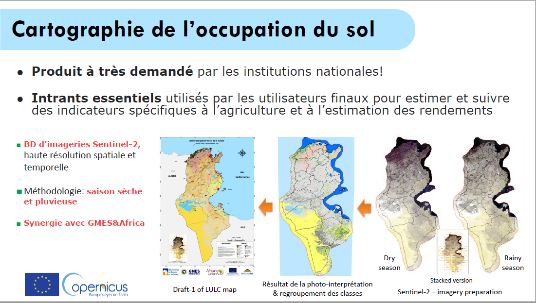
Presentation Evence Zoungrana
At the follow-up webinar in French that was held on May 31 2022, l’Afrique et les donnes spatiales Europeénnes, Evence Zoungrana gave a presentation on the use of Copernicus data for agricultural monitoring in Tunisia.
Click on the picture below to see the presentation.
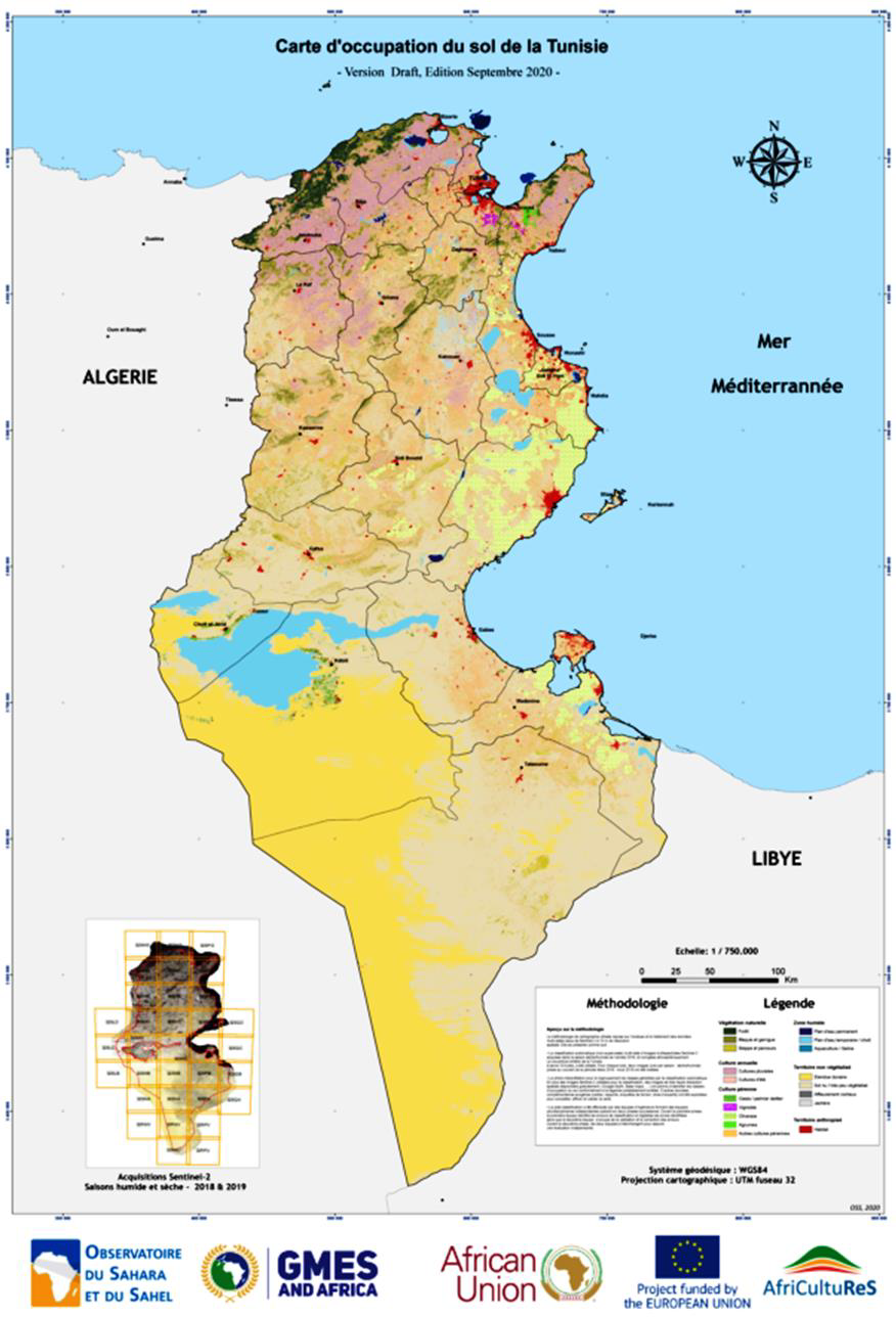
OSS reaches out to AfriCultuReS’ target groups
National and regional governments are interested in creating the conditions for increasing agricultural production and productivity and reducing risk. Earth observation is an excellent tool to support informed decision-making. With this in mind the Sahara and Sahel Observatory (OSS) held a national workshop for presenting the results of the AfriCultuReS project in Tunisia on December 15 and 16.
Links for other public deliverables:
D18 Data Procurement Plan
D05 Terms of Reference Advisory Board and Users' Board
D02 Data Management Plan
December 6, 2017
AfriCultuReS project uses EO to support farmers
November 29, 2017
Thirteen Consortia of Institutions to Implement the GMES and Africa Support Programme
| GMV | : | GMV Aerospace and Defense |
| AUTH | : | Aristotle University of Thessaloniki |
| CERSGIS | : | Centre for Remote Sensing and Geographic Information Services |
| CRA | : | Centre Régional Agrhymet |
| DRAXIS | : | Draxis Environmental Technologies |
| UEM | : | Universidade Eduardo Mondlane |
| GEOSAS | : | Geo-Space Analytical Services |
| HCP | : | HCP International |
| LocateIT | : | Locate IT |
| OSS | : | Observatoire du Sahara et du Sahel |
| SIA | : | Universita degli Studi di Roma La Sapienza |
| SANSA | : | South African National Space Agency |
| SMHI | : | Sveriges Meteorologiska och Hydrologiska Institut |
| UC | : | Universidad de Cantabria |
| UNIVLEEDS | : | University of Leeds |
| USFD | : | University of Sheffield |
| CGIS | : | University of Rwanda |
Regional Pastoral Information Service
in Niger

Click on the picture to download the PowerPoint presentation.


Selection of pilot areas and Earth observation application topics (poster GEO week Kyoto, Japan)


AfriCultuReS Ghana platform demo
AfriCultuReS South Africa platform demo
AfriCultuReS Mozambique platform demo
AfriCultuReS Niger platform demo
AfriCultuReS Tunisia platform demo
AfriCultuReS platform user manual
Click on the picture below to download the user manual for the AfriCultuReS platform.

Services in development (poster GEO week Canberra, Australia)

AfriCultuReS presented a poster at IGARSS July 2022
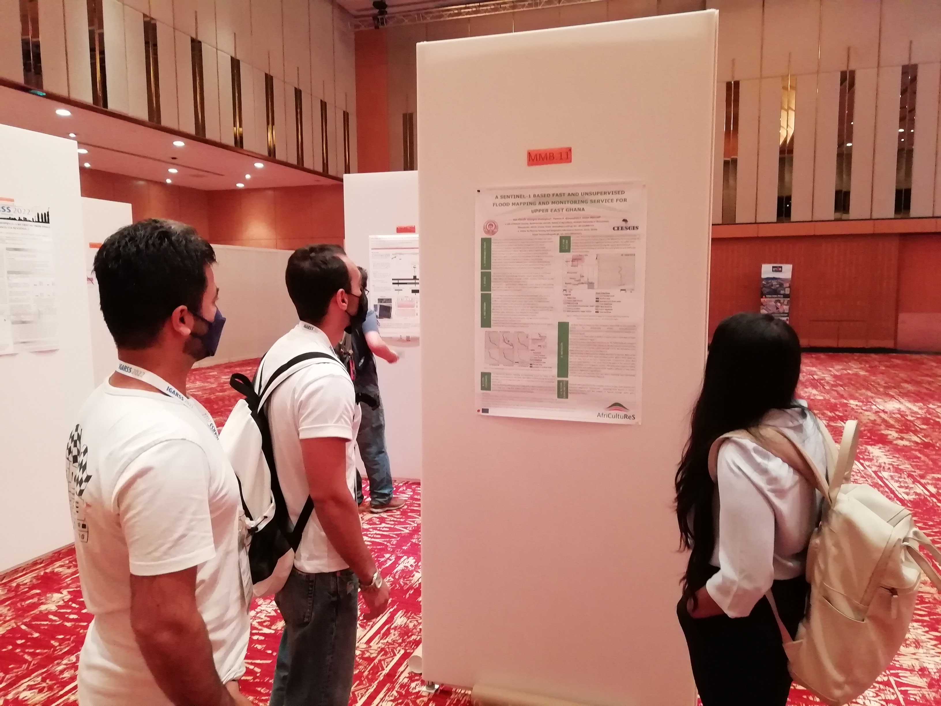 AfriCultuReS presented a poster at the International Geoscience and Remote Sensing Symposium (IGARSS), held in Kuala Lumpur, Malaysia, 17 - 22 July 2022, with the theme Preserving Our Heritage, Enabling Our Future Through Remote Sensing.
The title of the poster is “A Sentinel-1 based fast and unsupervised flood mapping and monitoring service for Upper East Ghana” and you can find it here.
Presentation Nosi Mashiyi
Click on the picture below for the link to Nosi Mashiyi’s presentation on the AfriCultuReS decision support system on Amazon web services, delivered at the GEO Virtual Symposium 2020.

Workshop OSS December 15 and 16 2020
National and regional governments are interested in creating the conditions for increasing agricultural production and productivity and reducing risk. Earth observation is an excellent tool to support informed decision-making. With this in mind the Sahara and Sahel Observatory (OSS) held a national workshop for presenting the results of the AfriCultuReS project in Tunisia on December 15 and 16 2020.
Presentations:
Preview of the AfriCultuReS service platform
Here you’ll find a preview of the services that are offered on the AfriCultuReS platform, together with demonstration use cases on cropland management, land use / land cover mapping, surface water bodies monitoring, water consumption monitoring, crop condition monitoring, and flood mapping and monitoring: http://africultures-platform.eu/demonstration-use-cases/.

Overview of the AfriCultuReS project
Go to the presentation of December 2020
Technical products and services
Presentation of technical products and services
Alexandridis, T. et al. (2020). Designing AfriCultuReS services to support food security in Africa. Transactions in GIS.
This article explains the principles behind the AfriCultuReS project that aims at improving the food security situation in Africa by developing services that integrate Earth observation with other data sources.
Check out the latest AfriCultuReS publication
 “Validation of sentinel-2 leaf area index (LAI) product derived from SNAP toolbox and its comparison with global LAI products in an African semi-arid agricultural landscape” by Mahlatse Kganyago, Paidamwoyo Mhangara,Thomas Alexandridis, Giovanni Laneve, Georgios Ovakoglou & Nosiseko Mashiyi.
AfriCultuReS publication
“Validation of sentinel-2 leaf area index (LAI) product derived from SNAP toolbox and its comparison with global LAI products in an African semi-arid agricultural landscape” by Mahlatse Kganyago, Paidamwoyo Mhangara,Thomas Alexandridis, Giovanni Laneve, Georgios Ovakoglou & Nosiseko Mashiyi.
How do you make remote sensing data work for diverse small-scale farmers and pastoralists in diverse African contexts?
By Brittany Bunce and Maurice Beseng 15.07.2021

In the last two decades, there has been a growing appeal to use data derived from Earth Observation (EO) to support sustainable development policies in Africa, especially in the agricultural sector where there is a lack of reliable and timely information. EO data such as satellite remote sensing is seen as a powerful tool to modernise the monitoring and improvement of agriculture on the continent. Globally, there are many Earth Observation for Development (EO4D) initiatives, and an increasing number focusing on Africa that draw on remote sensing data to support decision-making in agricultural practices such as land cover/ land use mapping, crop/vegetation monitoring and famine early warning. An example is the “Enhancing food security in African AgriCultural systems with the support of REmote Sensing (AfriCultuReS)- a European Union-funded Horizon 2020 Project, which is developing an integrated agricultural monitoring and early warning system that brings remote sensing data together with crop and climate models to inform decision-making, with the ultimate aim of improving food security in Africa. The platform will provide seven bundled services related to climate, drought, land, livestock, crops, water and weather. It is hoped that a diverse set of end-users will be able to make use of the final platform, including small-scale farmers and pastoralists as the primary producers, as well as actors in the agribusiness, public, financial and academic sectors, across eight African partner countries.
While projects such as AfriCultuReS indicate the immense interest and ambition to leverage EO4D, the path from satellite images to sustainable agricultural policies or services in Africa is not straightforward. There are increasing concerns that current efforts to create EO4D applications for African agricultural development are largely built on foreign engineering designs rooted in the North, are financially unsustainable and fail to grapple with the key constraints faced by end users in Africa. Hence, despite the palpable excitement around the potential of using remote sensing data for agricultural development, there remains reason to be cautious and to take stock of some of the shortcomings and limitations of technical fixes to Africa’s complex agrarian system.
Emerging voices on EO4D for African agriculture advocate partnering with end-users in the co-creation of EO products through all stages of their design, implementation and evaluation. In this context, ‘capacity development’ approaches are being reconceptualized to accommodate the need to improve the ability of technical developers to create data and services that more closely serve the needs of end users. This is a welcomed move away from the paternalistic and rather simplistic focus on ‘building’ the capacity of end users to understand EO data, that may or may not be asking the right questions and hence might be unable to solve the key challenges end users face on the ground.

Figure: Smallholder goat and mango farm, Tzaneen, Limpopo Province, South Africa (Photo Credit: Brittany Bunce)
Clearly, solving food security challenges across various African socio-political contexts requires a methodology that allows remote sensing data to be embedded more closely within the complexity of diverse African agrarian systems. The concept of crowdsensing is being promoted to allow for the gathering of important georeferenced data by farmers and other end users, which can be processed through apps and shared in a collective manner through mobile devices. Importantly, the resulting platforms should integrate indigenous knowledge systems and be able to respond to the varied specificities of smallholder production. Remote sensing platforms should be able to take account of this world of complex social and ecological relations, otherwise purely top-down interventions are unlikely to be effective and worse, are at risk of endangering livelihoods or reinforcing local inequalities.
A question foremost in our mind is how end users without technical expertise in remote sensing and GIS can practically make use of a remote sensing platform to inform decision-making processes that improve the resilience and productivity of their farming systems. This concern has been echoed by partners and potential end users in engagements hosted in AfriCultuReS partner countries. It was suggested that in order to achieve impacts on food security it would be necessary to develop more accessible and user-friendly ways to package the data and to target a diversified set of communication methods to address some of the systemic technology barriers in different contexts e.g. the high cost of data in many African countries. Hence the challenge for developers and for capacity development approaches, is to now devise ways in which this data can be rendered practical and participatory and literally put to work in the field to aid farmers and pastoralists.
A lot of progress has already been made to develop off-line, open-source apps targeted at smallholders and pastoralists (m-Agri Services). However, smartphone access is patchy, and so this approach risks excluding some stakeholders. For this reason, current lessons emerging from AfriCultuReS partners suggest the need to make use of existing communication networks, such as agricultural extension systems, farmer associations or other context specific social networks, or making use of more broadly available communication networks such as local radio, SMS or social media. However, even if a user-friendly interface for an app can be produced and other accessible ways to package the data can be devised, some caveats still remain. Developing capacity among data developers to create the right resources and among end users to understand the data, does not in itself ensure effective decision-making that promotes food security. In other words, what needs to be done to ensure end users are able to interpret the data provided, and then use it to make very practical production and investment decisions on farms, rangelands, in markets and policy spaces?
To this end, participatory learning and decision-making processes can be integrated to bridge the gap between the platform that is developed and decisions that are made on the farm. There are a number of initiatives that are developing innovative ways to do this, for example, the Participatory Integrated Climate Services for Agriculture (PICSA) approach, which has been used across 20 countries. PICSA provides a step-by-step participatory decision-making framework that allows farmers to work together with trained facilitators (e.g. extension officers) to analyze climate data, together with farm-level data and links them to practical management approaches for specific farms or rangelands. Conceivably a similar approach could be implemented to ensure the seven bundled services provided by AfriCultuReS can be of practical use to farmers and pastoralists, although a precise approach is still being designed.
Figure: Smallholder cabbage plot, Vryheid, KwaZulu-Natal Province, South Africa (Photo Credit: Brittany Bunce)
The strength of a participatory approach like PICSA, is that farmers and pastoralists are in the driving seat and are being supported to make informed decisions, rather than being told what to do by extension workers, a radio announcement or a ‘SMS push notification’, that wouldn’t be able to understand the specificities of their individual farms and livelihood systems. This kind of participatory approach embraces the farm as an integrated social system, rather than just a composite of crops and livestock. The remedy posed to the complexity of EO data, however, is usually to simplify it through something like a ‘SMS push notification’. However, in the case of EO4D, simplicity may be a misfit for a complex challenge like food security and so grappling with complexity may be well worth the effort to ensure we find effective ways to support smallholders and pastoralists.
Link to original blog
The right to water and food: digitalisation, informed decision-making, empowerment, inclusiveness & the rights-based approach
An important advantage of digitalisation and remote sensing in particular is that it facilitates informed decision-making, can serve as an instrument for empowerment (increased transparency) and supports inclusiveness. But how is this put into practice and take existing power relations into account?
Especially in the context of tackling poverty many factors play a role and often there are conflicts of interests (just look at history in general). In many cases investments of some sort are needed and politicians and administrators are very good at saying “we’ll look into it” very eloquently, which frequently leads to (indefinite) postponement.
An example from my own experience: As a young engineer I was involved in a protest march of indigenous people to the capital city claiming their right to drinkable water. As the recently elected president profiled himself as the president-of-the-poor there was no nice way to keep people out and the office of the vice-minister filled rapidly with poncho-clad representatives of the community. After a vivid discussion the vice-minister said that it was a complicated matter that needed more study. I intervened that we already had a technical design and substantial funding and that the only thing we needed from the government was about 20km of second-hand (note: not second-rate) steel tubes to cross a deep valley (which we knew the government had in store). Fortunately all this was already discussed with the technical people from the national water agency. Within five years the system was completed.
What did I learn from this?
1 A certain level of political will is required.
2 The community / communities concerned
need to be united behind the cause.
3 The solution needs to be clear, technologically
feasible and financially affordable.
For a long time I did not come across practical literature on this topic. But when doing a study on digitalisation for the Netherlands Ministry of Foreign Affairs I interviewed people from WWF and IUCN on an initiative called Shared Resources, Joint Solutions. They produced a small handbook on influencing. It has now disappeared from their website, although they have a lot of documents with examples of the rights-based approach. Therefore I present the main steps for action from the handbook here:
Ten steps to develop an effective influencing strategy:
1 Who are you? (Creating a manifesto of legitimacy,
which should determine whether, or not, power
holders will listen to your arguments and respect
your interests on the issue. This can be based on
e.g. mass mobilisation, expert knowledge or
personal relations).
2 What is the problem?
3 What policy has to change to solve the problem?
4 Who is the power holder of the policy change?
5 Where in the decision-making process are we?
6 Who are your friends (and not)?
(stakeholder (power) mapping)
7 What is your strategy to influence?
8 Make an activity plan.
9 Just do it! And monitor and learn from it.
10 Be flexible! Adjust your strategy to
new developments.
This leads to nine assignments to develop your influencing strategy:
* Who am I? Assignment #1: Write or draw a manifesto.
* What is the problem of the powerless? Assignment #2:
Formulate or draw the problem.
* What policy has to change to solve the problem?
Assignment #3: Formulate or draw the policy change.
* Who is the power holder of the policy change?
Assignment #4: Make a profile of the power holder.
* Where in the decision making process are we?
Assignment #5: Make a timeline of all the decisions
leading up to the policy change.
* Who are your friends (and not)?
Assignment #6: Build a partnership with allies.
* What is my strategy to influence? Assignment #7:
Work out an influencing strategy document.
* Make an Activity Plan? Assignment #8:
Make an activity plan and timeline.
* Do it! And monitor and learn from it! Assignment #9:
Do a reality check on the resources.
Indeed this is a recipe for lobbying, but the power dimensions that always play a role are addressed and there is a nice fit with the example I mentioned. We aim to take these lessons to heart in the development of services in the AfriCultuReS (http://www.africultures.eu) and TWIGA H2020 projects.
Work Package leader for WP3 “Data Harvesting and Service Portfolio Design and Prototyping”.
Task leader for Task 1.2 “Scientific & Technical Coordination”,
Task 3.1 “Earth Observation based Remote Monitoring” and
Task 3.4 “Data Fusion, Services Federation and Prediction Models”.
AUTH also contributes significantly to several tasks and activities across different WPs.![]()
Activity leader within Task 1.2 “Scientific & Technical Coordination”, providing support related to the West African territory.
CERSGIS also contributes significantly to several tasks and activities across different WPs.![]()
CGIS contributes significantly to several tasks and activities across different WPs.![]()
Activity leader within Task 1.2 “Scientific & Technical Coordination”, providing support related to the Sahel territory.
AGRHYMET contributes significantly to several tasks and activities across different WPs.![]()
Task leader for Task 3.2 “In-situ Monitoring” and
Task 4.1 “AfriCultuReS IT Services Platform Design and Development”.
DRAXIS also contributes significantly to several tasks and activities across different WPs.![]()
GeoSAS is the task leader for Task 2.2 “Assessment of EO & Enabling Technologies for Geospatial Decision”.
GeoSAS is activity leader within Task 1.2 “Scientific & Technical Coordination”, providing support related to the Great Horn of Africa territory.
GeoSAS also contributes significantly to several tasks and activities across different WPs.![]()
Task leader for Task 5.1 “Dissemination, Communication, Users and Stakeholders Engagement and Community Animation”.
HCP also contributes significantly to several tasks and activities across different WPs.![]()
Task leader for Task 4.2 “AfriCultuReS Services Integration and Testing”.
Activity leader within Task 1.2 “Scientific & Technical Coordination”, providing support related to the East African territory.
LocateIT also contributes significantly to several tasks and activities across different WPs.![]()
Activity leader within Task 1.2 “Scientific & Technical Coordination”, providing support related to the North Africa territory.
OSS also contributes significantly to several tasks and activities across different WPs.![]()
Task leader for Task 4.4 “AfriCultuReS Operational Demonstration and Users Appraisal”.
Activity leader within Task 1.2 “Scientific & Technical Coordination”, providing support related to the Southern African territory.
SANSA also contributes significantly to several tasks and activities across different WPs.![]()
Work Package leader for WP4 “Service Development, Integration and Testing, Validation and Demonstration”.
Task leader for Task 4.3 “AfriCultuReS Pre-operational Validation”.
SIA also contributes significantly to several tasks and activities across different WPs.![]()
Task leader for Task 3.3 “Weather Forecast, Seasonal Predictions & Climate Projections”.
SMHI also contributes significantly to several tasks and activities across different WPs.![]()
Within Task 3.3 “Weather Forecast, Seasonal Predictions & Climate Projections”, UC (in coordination with its linked third party, CSIC) coordinates activity 3.3b on “Seasonal forecast”.
UC also contributes significantly to several tasks and activities across different WPs.![]()
UEM contributes significantly to several tasks and activities across different WPs.![]()
Work Package leader for WP2 “AfriCultuReS Scoping and Framework and Requirements Assessment”.
Activity leader for 2.1b “Analysis of Agro-systems and Socio Economic Assessment”,
2.1c “Agricultural risk analysis” and
3.4a “Crop and grasslands growth modelling for yield prediction”.
UNIVLEEDS also contributes significantly to several tasks and activities across different WPs.![]()
Task leader for Task 5.2 “Empowerment and Capacity Building”.
USFD also contributes significantly to several tasks and activities across different WPs.![]()

South African National Space Agency
| Country | South Africa |
| Website | www.sansa.org.za |
Organisation
The mandate of SANSA is to coordinate and integrate space science and technology programmes, conduct long-term planning and implementation of space-related innovations in South Africa, and ensuring the supply of cost-effective space-based EO data and products to support South Africa’s policy, decision-making, economic growth and sustainable development.
Main tasks
Task Leader for Task 4.4
Activity Leader within Task 1.2
Staff members
Nosiseko Mashiyi (leader)
Mahlatse Kganyago (participant)
Clement Adjorlolo
Scientific articles AfriCultuReS
Click on the picture below to download the list with links to scientific articles of AfriCultuReS.

Scientific publication and technical report
A scientific publication was dedicated to the activities in Tunisia: “Supervised Machine learning for Crop mapping using Sentinel-2 time-series imageries - Case studies in Jendouba and Tunisia” (https://doi.org/10.4018/978-1-7998-1954-7.ch008). You also can find it here.
A report on the establishment of the national geoportal for Tunisia was published in June 2021. It is called “Développement d’une plateforme géospatiale dédiée à la diffusion des données cartographiques (Tunisie)” and available here.
Improving the AfriCultuReS seasonal forecast for Africa
By Sixto Herrera, University of Cantabria
The team from the University of Cantabria has worked on improving the seasonal forecast methodology from different viewpoints to assess whether it is possible to improve the forecasts for Africa and the AfriCultuReS' services. The work was done in collaboration with teams from outside the consortium and the study regions were also different but the results can be relevant for Africa as well.
Two studies focused on evaluating the calibration of different products, including the TRMM that is commonly used by the community and the seasonal forecast. When the calibration was applied to Africa the forecast didn't improve significantly and, for some countries it was worse, so efforts are made to get better results with different weather types, but it is currently a work in progress.
Second project meeting
The AfriCultuReS project held its second progress meeting in November 2018 in Pretoria, South Africa, organised by SANSA.


The meeting focused on the analysis of user needs that were identified in the regional stakeholder requirement workshops and how to match these with technical solutions based on satellite information to achieve maximum impact for food security.
AfriCultuReS Niger services demo
AfriCultuReS Mozambique services demo
AfriCultuReS South Africa services demo
AfriCultuReS Tunisia services demo
University of Rome 'La Sapienza'
| Country | Italy |
| Website | www.uniroma1.it |
Organisation
The University of Rome 'La Sapienza' contributes through the School of Aerospace Engineering (SIA) which is a Faculty funded in 1926 as School of Aeronautics Engineering and in 1961 became School of Aerospace Engineering. EOSIAL (Earth Observation Satellite Images Applications Lab) is a laboratory of the School devoted to developing applications, based on the exploitation of satellite images.
Main tasks
Work Package Leader for WP4
Task Leader for Task 4.3
Staff members
Giovanni Laneve (leader)
Lorenzo Fusilli (participant)
Roberto Luciani (participant)
Swedish Meteorological and Hydrological Institute
| Country | Sweden |
| Website | www.smhi.se/en |
Organisation
SMHI is a government agency under the Swedish Ministry of Environment and Energy. SMHI provides decision support to a broad range of end-users, based on meteorology, hydrology, oceanography and climate information.
Main tasks
Task Leader for Task 3.3
Staff member
Grigory Nikulin (leader)

Space-based services for smallholders: what have we learned?
The Geodata for Agriculture and Water Facility (G4AW) provided co-financing grants to 25 projects in Africa and Asia (23 targeted smallholder farmers and 2 targeted pastoralists). Each project’s objective within this Facility was to reach 100,000 farmers (or 50,000 pastoralists) and create a sustainable business model. The satellite-based services that were part of the portfolio offered were: weather information and forecasts, good agricultural practices, crop management and (index) insurance. For pastoralists information on (good quality) water and pasture was provided.
What have we learned? Some key findings:
There is no one-size-fits-all approach to creating successful digital agriculture advisory services. A key factor is how partnerships develop and adopt the right business model for service uptake. The presence of a large agro-business, insurer, bank or telecom company in the partnership creates favourable conditions for reaching food producers and bundling with other services.
For more info, including the recommendations, go to the publication
Comparison of the spatial detail between a MODIS LAI image (a) and a downscaled LAI image (b) for the Umbeluzi study area (Mozambique)

Comparison of the spatial detail between a MODIS LAI image (a) and a downscaled LAI image (b) for the Umbeluzi study area (Mozambique)
Comparison of the spatial detail between a MODIS LAI image (a) and a downscaled LAI image (b) for the Umbeluzi study area (Mozambique)
 |
Thomas Alexandridis (leader) |
|
 |
Dimitrios Moshou (task leader) |
|
 |
Eleni Katragkou (task leader) |
|
 |
Ioannis Pitharoulis (task leader) |
|
 |
Afroditi Alexandra Tamouridou (participant) |
|
 |
Xanthoula Eirini Pantazi (participant) |
|
 |
Ines Cherif (participant) |
|
 |
Dimitris Kasampalis (participant) |
|
 |
George Ovakoglou (participant) |
|
 |
Iordanidis Charalampos (participant) |
|
 |
Maria Karypidou (participant) |
|
 |
Stergios Kartsios (participant) |
|
|
Dimitris Kasampalis (participant) |
||
|
Stergios Kartsios (participant) |
||
|
Maria Karypidou (participant) |
||
|
Natasa Bougeli (participant) |
Foster Mensah (leader)
 |
Clarisse Kagoyire (leader) |
|
|
Elias Nyandwi (participant) |
||
|
Gaspard Rwanyiziri (participant) |
||
|
Joseph Tuyishimire (participant) |
Issa Garba (leader)
Amina Oumarou (participant)
Alio Agoumo (participant)
Binta Zalagou (participant)
Stelios Kotsopoulos (leader)
Stavros Tekes (task leader)
Woldeamlak Bewket (leader)
Teklemariam Haile (leader)
Teame Tewolde-Berhan (participant)
Asnake Mekuyiam (participant)
|
Mark Noort (leader) |
Vivianne Meta (leader)
Steve Omondi (participant)
Vance Udoto (participant)
Nabil Ben Khatra (leader)
Louis Evence Zoungrana(task leader)
Mustapha Mimouni (participant)
Ndeye Fatou Mar (participant)
Nosiseko Mashiyi (leader)
Mahlatse Kganyago (participant)
Clement Adjorlolo
Giovanni Laneve (leader)
Lorenzo Fusilli (participant)
Roberto Luciani (participant)
Grigory Nikulin (leader)
 |
Sixto Herrera (co-leader) |
|
 |
Jose Manuel Gutierrez (co-leader, third party of the UC) |
|
 |
Rodrigo García Manzanas (task leader) |
|
 |
Antonio S. Cofiño (participant) |
Tomás Chiconela (leader)
Ivan Remane (participant)
Jadwiga Massinga (participant)
Andy Challinor (leader)
Stewart Jennings (participant)
Kanhu Pattnayak (participant)
Dan Brockington (leader)
Dorothea J Kleine (participant)
Rose Pritchard (participant)
Integrated agricultural monitoring and early warning system
AfriCultuReS aims to design, implement and demonstrate an integrated agricultural monitoring and early warning system that will support decision making in the field of food security. AfriCultuReS delivers a broad range of climatic, production, biophysical and economic information, for various regions in Africa. AfriCultuReS applies geospatial science to sustainable agricultural development, natural resource management, biodiversity conservation, and poverty alleviation in Africa.
Key players
AfriCultuReS, supported by the GEO Secretariat, involves all key players of AfriGEOSS, GEOGLAM, SIGMA, ARTEMIS, African Drought Observatory and other initiatives as well as partners representing the diversity of African agricultural systems, in an effort to push forward the services provided by current systems, with innovative fusion of data from multiple sources (EO, in-situ, citizen-based crowdsourcing, climate services and weather, crop models) in a vertical manner. Crop yield and biomass prediction models is enhanced through the fusion of EO data and climate models, emphasizing the use of the complementary sensors of the EU Sentinels constellation.
Geospatial products are combined in a spatial Decision Support System (DSS) to enrich decision making and risk assessment. The geo component of the DSS is compliant with the GEO’s interoperability standards, allowing its integration with the current services of the GEOSS Common Infrastructure.
African networks
The African partners and collaborating networks are essential for local training and promoting further use of the project tools. Social innovation is used to increase the number of involved stakeholders and to boost the flow of information in a user-friendly manner. The final target is to produce a web tool that supports early decision-making for the stakeholders of African food production.
Tele-training by OSS
OSS organised a “Tele-training on operational modelling of wheat growth and its yield estimate” within the framework of the AfriCultuReS and GMES-Africa projects in partnership with the CNCT (National Center for Mapping and Remote Sensing) - ONAGRI (National Observatory of Agriculture) and INRGREF (National Institute for Research in Rural Engineering, Water and Forests), from 20 to 22 April 2020.
Concept note (English)
Concept note (French)
Report on the methodology
If you are interested in doing the training yourself, please contact Evence Zoungrana at louis.zoungrana@oss.org.tn
For the links to presentations on monitoring campaigns in Tunisia and presentations of the AfriCultuReS consortium click on more...
Third project meeting

The project partners met in Thessaloniki, Greece, on May 20 and 21 to discuss future plans. Seven main service categories were identified:

University of Cantabria
| Country | Spain |
| Website | www.meteo.unican.es |
Organisation
UC has leading research groups at European and International level in environmental sciences, including climate science (the UC Meteorology Group). Most of these groups are involved in sustainable development policies.
Main tasks
Coordinator activity 3.3b within Task 3.3
Staff members
Sixto Herrera (co-leader)
Jose Manuel Gutierrez (co-leader, third party of the UC)
Rodrigo García Manzanas (task leader)
Antonio S. Cofiño (participant)
Eduardo Mondlane University
| Country | Mozambique |
| Website | www.uem.mz |
Organisation
The UEM team has worked in research projects related with agronomy for more than 15 years which resulted in a build-up of local knowledge on soil use and land cover, plant growth, agriculture practices and assessment of the drivers of deforestation and forest degradation in Mozambique.
Main tasks
Contribution to several tasks and activities across different WPs
Staff members
Tomás Chiconela (leader)
Ivan Remane (participant)
Jadwiga Massinga (participant)
University of Leeds
| Country | United Kingdom |
| Website | www.see.leeds.ac.uk |
Organisation
The School of Earth and Environment (SEE) at the University of Leeds is an internationally recognised centre for research and teaching in earth and environmental system science and social science.
Main tasks
Work Package Leader for WP2
Activity Leader for 2.1b, 2.1c 3.4a
Staff members
Andy Challinor (leader)
Stewart Jennings (participant)
Kanhu Pattnayak (participant)
Unstable situation in Ethiopia
Due to the unstable situation in Ethiopia information on the Ethiopia use case on crop mapping for the production of crop statistics will become available later than anticipated.
Unstable situation in Ethiopia
Due to the unstable situation in Ethiopia information on the Ethiopia use case on crop mapping for the production of crop statistics will become available later than anticipated.
Unstable situation in Ethiopia
Due to the unstable situation in Ethiopia information on the Ethiopia use case on crop mapping for the production of crop statistics will become available later than anticipated.
Alleviating adverse impacts of drought on livestock farmers in South Africa
 Click on the picture to download the PowerPoint presentation.
AfriCultuReS Tunisia use cases presentation in French
AfriCultuReS Mozambique use cases presentation in Portuguese
| Abel Ramoelo | Regional Ecologist / EO Specialist | South African National Parks (SANParks) |
| Milagre Nuvunga | Executive Director | MICAIA Foundation |
| Marta Villa | Director General | Women for Africa Foundation |
| Sarah Conradt | Agricultural Modeller and Risk Analyst | SCOR |
University of Sheffield
| Country | United Kingdom |
| Website | siid.group.shef.ac.uk |
Organisation
Sheffield Institute for International Development (SIID) is an interdisciplinary research centre with expertise drawn across the University. Specialist themes include natural resources and rural livelihoods, and data, digital technology and innovation.
Main tasks
Task Leader for Task 5.2
Staff members
Dan Brockington (leader)
Dorothea J Kleine (participant)
Rose Pritchard (participant)

AfriCultuReS Kenya use cases presentation
AfriCultuReS Kenya services demo
AfriCultuReS Kenya platform demo
AfriCultuReS Rwanda services demo
AfriCultuReS Rwanda platform demo
1st Virtual Practitioners Conference
on Desert Locust Management 2020 (August 10)
Locust outbreaks in 2019-20 in East Africa and West Asia have been the worst in decades. They have already wiped out massive amounts of crops, vast swathes of pasture. The sheer size of swarms and the sheer amount of food they devour within a matter of hours is triggering hunger crises—from Kenya and Ethiopia to Pakistan and India, and even Argentina most recently. In East Africa alone, 19 million are at risk of a much bigger crisis if the infestation continues unabated.
The 1st Virtual Practitioners Conference on Desert Locust Management 2020 (August 10), hosted by TheWaterChannel and supported by a number of partner organisations, will bring together professionals working at the frontline of the locust crisis across the world. They will present and discuss the nature of the problem as experienced at global and local levels, and the most promising solutions going forward.
To go to the recordings of the various sessions click on the picture below

Water services
 Climate change will impact the global hydrological cycle and therefore affects the patterns of demand and supply of water for agriculture, the dominant user of freshwater.
The extent and productivity of both irrigated and rainfed agriculture are expected to change. Adaptation measures that build upon improved land and water management practices are fundamental to ensure food security and to increase resilience to climate change.
The AfriCultuReS water service is part of a portfolio of services that can be combined for different applications. The other services are climate, crop, drought, land, livestock and weather.
Click on the picture below to download the brochure.

Products
To see our water services products, click on more...
Water bodies detection in South Africa
Accurate assessment of available water resources is vital for humans and the environment. Have a look at the latest AfriCultuReS article on improving detection of water bodies in South Africa by Ines Cherif, Georgios Ovakoglou, Thomas Alexandridis, Mahlatse Kganyago and Nosiseko Mashiyi.
Water Bodies Extent, Status and Quality Mapping in Kenya

Click on the picture to download the PowerPoint presentation.
Weather services
 The weather has a big influence on food production and extreme weather can affect food security in a very negative way. Climate change will likely cause more occurrences of extreme weather, increasing the probability of food shortages. The provision of accurate and timely weather forecasts is therefore very important and a requisite for good day-to-day farm management. Weather conditions are also used to predict the outbreak of pests and diseases and the onset of droughts and heat waves. Knowing in advance the likelihood of these events helps prevent loss of crops and livestock.
The AfriCultuReS weather service is part of a portfolio of services that can be combined for different applications. The other services are climate, crop, drought, land, livestock and water.
Click on the picture below to download the brochure.

Products
To see our weather services products, click on more...
Weather forecasting for agriculture in Africa,
the business case?
 TWIGA team visiting a TAHMO weather station in Ghana
(courtesy: TAHMO & TWIGA project)
Weather information is a priority for farmers, whether they use irrigation or not. It should be localised, timely and accurate enough, to make the information relevant at field level. In Africa, this is often not the case, although there are information providers, such as aWhere and Weather Impact, that are active on the continent.
There is a clear need for local meteo stations, not only for increasing the density of the meteorological observation network, but also for other parameters. To give an example: humidity is very important for to assess the conditions in which late blight disease in potatoes can occur (information derived from satellites only is not accurate enough).
An organisation that aims at filling this gap is TAHMO. TAHMO has now 400 stations and plans to go to 20,000 meteo stations quickly.
Weather forecasting for agriculture in Africa, the business case?
Weather information is a priority for farmers, whether they use irrigation or not. It should be localised, timely and accurate enough, to make the information relevant at field level. In Africa, this is often not the case, although there are information providers, such as aWhere and Weather Impact, that are active on the continent.
There is a clear need for local meteo stations, not only for increasing the density of the meteorological observation network, but also for other parameters. To give an example: humidity is very important for to assess the conditions in which late blight disease in potatoes can occur (information derived from satellites only is not accurate enough). An organisation that aims at filling this gap is TAHMO. TAHMO has now 400 stations and plans to go to 20,000 meteo stations quickly.
But who pays for all this? Cooperation with national meteo agencies is a must, but the budget available is limited. Advertising, as with weather forecasting in developed countries (e.g. buienradar (shower radar) in the Netherlands) is not an option in Africa. In addition, these applications provide their information on the web, while in Africa transmission through SMS and IVR would be more appropriate and needs to be done in the local language(s).
An option is to provide weather forecasting in combination with other services. This could be an inclusive model, paid for in combination with other services in a package, such as agricultural advice. Another option is to make use of a loyalty model: offer weather forecasting in combination with fertiliser or pesticides (paid for by the supplier of these inputs). Weather forecasting can also be considered as a public good. It can then be offered in a service model, paid for by the government, such as the AgriCloud app (a cooperation between the South African Weather Service (SAWS), Hydrologic and others that provides very important and much needed information on the start of the rainy season.
See also “Get this weather app on your cell phone” by Nico Kroese. Here the government has to step in to perform a public function by reducing risk and increasing production and, of course, by paying for the service. And all this does not even take the context of climate change into account that makes weather forecasting even more important and relevant.
If anyone has examples of successful weather forecasting applications that have found a sustainable business model, you are very welcome to share them with me!
| WP 1 | Project Management and Scientific & Technical Coordination |
| WP 2 | AfriCultuReS Scoping and Framework and Requirements Assessment |
| WP 3 | Data Harvesting and Service Portfolio Design and Prototyping |
| WP 4 | Service Development, Integration and Testing, Validation and Demonstration |
| WP 5 | Communication, Capacity Building and Sustainability and Exploitation Plan |
AfriCultuReS user requirements stakeholder workshops
In 2018 workshops were held in Ghana, Ethiopia, Kenya, Rwanda, Mozambique and South Africa to assess user needs related to Earth observation for food security.
 Workshop participants Ghana
AfriCultuReS user requirements stakeholder workshops
Workshops were held in Ghana, Ethiopia, Kenya, Rwanda, Mozambique and South Africa to assess user needs related to Earth observation for food security. The photos below give an impression of the workshops. Additional workshops are scheduled for Tunisia and Niger. The Business Daily wrote an article on the stakeholder workshop held in Kenya:
“Timely data will unlock farming potential, tech experts advise”.
Workshop participants Kenya
AfriCultuReS user requirements stakeholder workshops
In 2018 workshops were held in Ghana, Ethiopia, Kenya, Rwanda, Mozambique and South Africa to assess user needs related to Earth observation for food security.
 Workshop participants Rwanda
AfriCultuReS user requirements stakeholder workshops
In 2018 workshops were held in Ghana, Ethiopia, Kenya, Rwanda, Mozambique and South Africa to assess user needs related to Earth observation for food security.
 Workshop participants working in groups, Mozambique
AfriCultuReS user requirements stakeholder workshops
In 2018 workshops were held in Ghana, Ethiopia, Kenya, Rwanda, Mozambique and South Africa to assess user needs related to Earth observation for food security.
 Workshop participants South Africa
User workshop 3rd October
The fourth AfriCultuReS User Workshop of 2019 was organised by LocateIT and held in Nairobi on 3rd October. This workshop brought together representatives from government departments, research institutions and universities, farmers’ organisations, private enterprise and intergovernmental organisations to explore how AfriCultuReS can best meet user needs and build user capacity in Kenya.
Speaking during the opening address, Prof. Hamadi Boga, The State Department for Crop Development and Agriculture Research Principal Secretary, said that the ministry is developing a centralised, digitised information and knowledge portal where agricultural stakeholders can have access to production information on food and nutrition security. He expressed high hopes that AfriCultuReS will be high-quality research that will create data for Kenya.

Participants in the workshop in Kenya once again highlighted the importance of collaboration and integration, particularly given the number of Earth Observation for Sustainable Development (EO4SD) initiatives currently operational in the country. They suggested a need for agility to cope with a rapidly changing context, as the priority problems of today may not be those of tomorrow and lack of flexibility may result in the creation of products which quite quickly become obsolete.
 Understanding this evolving context means continually engaging with the diversity of agricultural stakeholders in Kenya and particularly with the diversity of farmers. Users reiterated the need to demystify solutions by simplifying them for the different levels of target users. For instance, disseminating information to pastoralists in Northern Kenya, would require the development of an entirely different communication strategy, potentially one based on existing social and business networks such as those centred around water point managers, elder associations or agrodealerships. Encouraging uptake of EO4SD applications will also involve creating simplified products which elegantly meet the core needs of end-users, and demystifying these products so that end-users fully understand the contributions earth observation-based applications can make to farming livelihoods.
User workshop 27th September
The third AfriCultuReS User Workshop of 2019 was hosted by the Centre for GIS and Remote Sensing of the University of Rwanda on 27th September 2019. This workshop included representatives from local and national government departments, research/academia, and farmers’ organisations.
The workshop showed the importance of integrating AfriCultuReS products and services into the rapidly evolving Rwandan geospatial sector. There are an increasing number of earth observation based products available in Rwanda and an increasing number of locally-produced high-resolution ground datasets. This offers exciting potential for collaboration, but brings with it an accompanying risk of duplication and redundancy. Meaningful partnerships with Rwandan institutions will therefore be essential to the success of any new project.

User workshop 17th September 2019
 The first of the AfriCultuReS 2019 User Workshops was held at the Innovation Hub in Pretoria on 17th September. Organised by the South African National Space Agency (SANSA), this workshop brought together representatives from government departments, research institutions, agribusiness and private enterprise to discuss the progress of the AfriCultuReS project and the priority capacity development needs in South Africa.
Earth observation for food security in Ghana
The third AfriCultuReS hybrid workshop for Ghana was held in Accra on March 23.
Earth observation for food security in Kenya
The third Kenyan AfriCultuReS hybrid workshop was held in Nairobi on March 16.
The experts like the following aspects of the AfriCultuReS platform (https://africultures-platform.eu/):
the broad variety of use cases and relevant services, the continuity of data streams, the possibility to add your own data, the visualisation and outlook of the platform and the automatic updates.
Opinions differed on the user friendliness of the platform. This has to do with the level of expertise required: the platform is considered user-friendly for those in the know about GIS and remote sensing, but not for non-specialists.
The slow loading of the platform affects the speed of accessing the products and this was considered a point for improvement. Another point of concern that needs to be addressed urgently was the guarantee for long-term sustainability of the platform.
Apart from some technical points, recommendations related to a more prominent search function and a demonstrated interoperability with other platforms. Adaptation to local conditions was a general recommendation, concerning both adjustment to the specific needs of different government agencies (leading to more direct decision support) and the ability to adapt to Kenyan farming reality, which requires high resolution imagery. The need for user manuals, instruction videos and training was also clearly expressed.
The following application areas were highlighted: rangeland monitoring, land use and land use change, climate change and seasonal forecasts, early warning related to drought and water quality, land degradation assessment, crop phenology, crop monitoring, yield estimation and harvested area determination.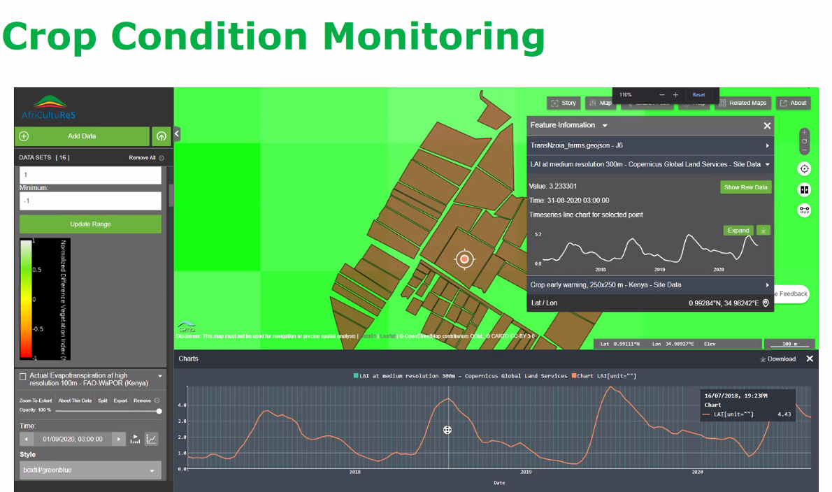
Earth observation for food security in Rwanda

The third AfriCultuReS hybrid workshop was held in Kigali on March 11.
Earth observation for food security in Mozambique
The AfriCultuReS workshop for Mozambique was held on February 25.

Earth observation for food security in South Africa
The third AfriCultuReS workshop was held on Tuesday February 22 with special attention for the AfriCultuReS platform on Earth observation for food security: https://africultures-platform.eu/ 
Earth observation for food security in Niger
The AfriCultuReS platform (https://africultures-platform.eu/) was the main topic of discussion during the AfriCultuReS Niger workshop of March 3.

Earth observation for food security in Ghana
The third AfriCultuReS hybrid workshop for Ghana was held in Accra on March 23.
Below you find the assessment of the expert users, who looked at the the AfriCultuReS platform (https://africultures-platform.eu/):
They found the portal interactive (possibility to import and add layers), they liked the availability of time series, the quality graphics, the option to download data and particularly that you can access and compare data from other countries.
On the minus side they found that navigation is not always easy, that the platform is not compatible with various internet browsers, that some data cannot be downloaded and that there is a certain dependency on a reliable and good internet connection.
Logically, the advice was to work on these points. In addition the experts advised to provide a user manual, tutorials and instruction videos (already in the planning). Platform users also need GIS and remote sensing training plus training in cloud computing. Other suggestions were to add a feedback option, a user survey and online help.
User workshop 3rd October
The fourth AfriCultuReS User Workshop of 2019 was organised by LocateIT and held in Nairobi on 3rd October. This workshop brought together representatives from government departments, research institutions and universities, farmers’ organisations, private enterprise and intergovernmental organisations to explore how AfriCultuReS can best meet user needs and build user capacity in Kenya.
Speaking during the opening address, Prof. Hamadi Boga, The State Department for Crop Development and Agriculture Research Principal Secretary, said that the ministry is developing a centralised, digitised information and knowledge portal where agricultural stakeholders can have access to production information on food and nutrition security. He expressed high hopes that AfriCultuReS will be high-quality research that will create data for Kenya.
Participants in the workshop in Kenya once again highlighted the importance of collaboration and integration, particularly given the number of Earth Observation for Sustainable Development (EO4SD) initiatives currently operational in the country. They suggested a need for agility to cope with a rapidly changing context, as the priority problems of today may not be those of tomorrow and lack of flexibility may result in the creation of products which quite quickly become obsolete.Understanding this evolving context means continually engaging with the diversity of agricultural stakeholders in Kenya and particularly with the diversity of farmers. Users reiterated the need to demystify solutions by simplifying them for the different levels of target users. For instance, disseminating information to pastoralists in Northern Kenya, would require the development of an entirely different communication strategy, potentially one based on existing social and business networks such as those centred around water point managers, elder associations or agrodealerships. Encouraging uptake of EO4SD applications will also involve creating simplified products which elegantly meet the core needs of end-users, and demystifying these products so that end-users fully understand the contributions earth observation-based applications can make to farming livelihoods.
Earth observation for food security in Kenya
The third Kenyan AfriCultuReS hybrid workshop was held in Nairobi on March 16.
The experts like the following aspects of the AfriCultuReS platform (https://africultures-platform.eu/):
the broad variety of use cases and relevant services, the continuity of data streams, the possibility to add your own data, the visualisation and outlook of the platform and the automatic updates.
Opinions differed on the user friendliness of the platform. This has to do with the level of expertise required: the platform is considered user-friendly for those in the know about GIS and remote sensing, but not for non-specialists.
The slow loading of the platform affects the speed of accessing the products and this was considered a point for improvement. Another point of concern that needs to be addressed urgently was the guarantee for long-term sustainability of the platform.
Apart from some technical points, recommendations related to a more prominent search function and a demonstrated interoperability with other platforms. Adaptation to local conditions was a general recommendation, concerning both adjustment to the specific needs of different government agencies (leading to more direct decision support) and the ability to adapt to Kenyan farming reality, which requires high resolution imagery. The need for user manuals, instruction videos and training was also clearly expressed.
The following application areas were highlighted: rangeland monitoring, land use and land use change, climate change and seasonal forecasts, early warning related to drought and water quality, land degradation assessment, crop phenology, crop monitoring, yield estimation and harvested area determination.
Earth observation for food security in Mozambique
The AfriCultuReS workshop for Mozambique was held on February 25.
The experts who assessed the AfriCultuReS platform (see https://africultures-platform.eu/) liked
the easily accessible interface, the user-friendliness of the platform and that a lot of data are offered at low or no cost. A minus is that there is (still) no option to add your own data and that bad connectivity may slow down navigation and downloading data.
They advised to provide a translation into Portuguese and to provide training in the use of the platform for different target groups, such as policy makers, extension workers and farmers. An extension of use cases for Mozambique was requested that includes more crops and attention for rainfed agriculture. More specific topics were also mentioned, such as land degradation maps, very high resolution imagery for monitoring of dykes, assessment of hay production for livestock and development of mobile apps for farmers.
The easy access to high resolution images, the demarcation of different types of land use (forest, agriculture), provision of information on climate and many aspects related to agriculture and the availability of time series that allow identification of trends (deforestation, production, etc.) were considered especially useful.
Earth observation for food security in Niger
The AfriCultuReS platform (https://africultures-platform.eu/) was the main topic of discussion during the AfriCultuReS Niger workshop of March 3.
This is the opinion of the experts:
many services and products are offered, the design is user-friendly, the platform is easily accessible and multi-functional. A downside is that a good internet connection is needed, but not always available in Niger.
A French version was requested, instruction tutorials and videos are very much needed and the possibility to integrate your own data into the platform and to overlay different types of data would be very much appreciated. Special attention should be given to non-GIS and remote sensing experts as users. Specific requests related to more information about quantified biomass, soil fertility maps and a good link with transmission channels that are used to convey messages and warnings to farmers.
The fact that lots of data on different topics are available was considered very useful. Biomass monitoring, fire monitoring, water bodies monitoring, soil degradation and drought monitoring were mentioned as topics of interest for which the platform could be used.
Workshop OSS October 29 and 30 2019
On October 29 and 30 a workshop was held on feedback of the thematic studies and the assessment of the end user needs for the application of Earth observation for food security.
Click for the concept note
For the links to all presentations click on more...
Workshop OSS December 15 and 16 2020
National and regional governments are interested in creating the conditions for increasing agricultural production and productivity and reducing risk. Earth observation is an excellent tool to support informed decision-making. With this in mind the Sahara and Sahel Observatory (OSS) held a national workshop for presenting the results of the AfriCultuReS project in Tunisia on December 15 and 16 2020.
Click for the announcement of the workshop (in French)
Click for the leaflet (in French)
For the links to all presentations click on more...
Workshop OSS 2021
The 4th AfriCultuReS workshop of OSS was held on December 15 and 15, 2021 with the aim to present the AfriCultuReS services and products and the results of the project in Tunisia. The videos of the services, the platform demonstration and the uses cases in Tunisia can be found on this webpage.
Concept note of the event (English)
Concept note of the event (French)
For the links to the presentations click on more...
User workshop 27th September
The third AfriCultuReS User Workshop of 2019 was hosted by the Centre for GIS and Remote Sensing of the University of Rwanda on 27th September 2019. This workshop included representatives from local and national government departments, research/academia, and farmers’ organisations.
The workshop showed the importance of integrating AfriCultuReS products and services into the rapidly evolving Rwandan geospatial sector. There are an increasing number of earth observation based products available in Rwanda and an increasing number of locally-produced high-resolution ground datasets. This offers exciting potential for collaboration, but brings with it an accompanying risk of duplication and redundancy. Meaningful partnerships with Rwandan institutions will therefore be essential to the success of any new project.
Discussion of capacity development priorities highlighted the limited technological infrastructure in Rwanda available to support new applications, and the funding constraints which make it difficult to address these infrastructure gaps. The preference of stakeholders would of course be to invest in improved infrastructure; but given that this is unlikely to be achieved in the near-term, emphasis was placed on the importance of offline functionality. Participants also highlighted the need for training adapted to the requirements of different stakeholder groups, for example through technical sessions, workshops, classroom training, or via media such as radio which are in Kinyarwanda and which have broad reach in the country.Our thanks to CGIS and particularly to Clarisse Kagoyire, Maurice Mugabowindekwe and Joseph Tuyishimire for organising the workshop, and to all the attendees for taking the time to participate and share their perspectives.
A full report on the outcomes of the 2019 AfriCultuReS User Workshops will be available on the website in early 2020.
Earth observation for food security in Rwanda
The third AfriCultuReS hybrid workshop was held in Kigali on March 11.
This is what the experts said about the AfriCultuReS platform (https://africultures-platform.eu/):
the platform helps improve crop monitoring, it is rich in content and combines different types of data from a variety of sources in one platform, it is easily updatable and data access is also easy, it is user friendly, open source and supports the digital transformation of agriculture.
Points for improvement: the platform is not suitable for non-expert users (policy makers, farmers), the resolution is not high enough for some applications (for individual smallholder farmers, areas with a lot of mixed cropping), the good internet connection that is needed is not always available and data export is not easy.
The experts advised to make the platform available in the local language, to make integration with data and platforms of government agencies possible, to add other data needed to make Rwandan uses cases relevant, to add a search/query option and to provide training for local, non-expert users.
They considered the platform particularly useful for crop monitoring, crop index insurance, crop phenology, climate services, land and water monitoring and food security early warning.
User workshop 17th September 2019
The first of the AfriCultuReS 2019 User Workshops was held at the Innovation Hub in Pretoria on 17th September. Organised by the South African National Space Agency (SANSA), this workshop brought together representatives from government departments, research institutions, agribusiness and private enterprise to discuss the progress of the AfriCultuReS project and the priority capacity development needs in South Africa.
Workshop discussions illuminated the vibrant Earth Observation for Sustainable Development scene existing in South Africa, and how important it is for new projects to understand this scene in order to avoid replicating existing products. Workshop participants stressed the importance of engaging with stakeholders at all stages of the value chain associated with a new agricultural application based on satellite earth observation, from product developers to the farmers themselves. Participants also discussed potential business models for new applications based on satellite earth observation in South Africa – all participants had witnessed projects which collapsed after initial funding had run out, and so financial sustainability was a key concern.
Capacity development priorities identified for South Africa included raising of awareness about the value of satellite earth observation among all stakeholders, for example through training-of-trainers workshops and dissemination of success stories. Participants also highlighted the challenges of disseminating information in rural South African contexts, particularly to poorer and otherwise marginalised farmers, and suggested a need to use communication strategies such as radio and SMS in local languages for information sharing.
Our thanks to SANSA and particularly to Nosiseko Mashiyi and Mahlatse Kganyago for leading the organisation of the workshop, and to all the workshop participants for sharing their time and experience.
A full report on AfriCultuReS 2019 workshop outcomes will be available on the website in early 2020.
Earth observation for food security in South Africa
The third AfriCultuReS workshop was held on Tuesday February 22 with special attention for the AfriCultuReS platform on Earth observation for food security: https://africultures-platform.eu/
Experts liked
the open source platform, the visualisation, the easy access and that the platform is a one stop shop for Earth observation dedicated to agriculture. The availability of time series with good frequency and the integration of different types of information are also strong points. The platform is considered a great enabler for capacity building.
Navigation was sometimes difficult and the resolution too coarse for specific applications. A user manual, demonstration videos and tutorials were recommended. The download functionality, webmap links and the legend description could be improved.
For rangeland health, which is the AfriCultuReS use case for South Africa, a layer indicating the browsing and grazing capacity could be added. All in all the availability of high resolution data for your own area of interest with already validated products was assessed as very positive.
AfriCultuReS user requirements stakeholder workshops
Workshops were held in Ghana, Ethiopia, Kenya, Rwanda, Mozambique and South Africa to assess user needs related to Earth observation for food security. The photos below give an impression of the workshops. Additional workshops are scheduled for Tunisia and Niger. The Business Daily wrote an article on the stakeholder workshop held in Kenya:
“Timely data will unlock farming potential, tech experts advise”.
Workshop participants Kenya
Workshop participants Ghana
Workshop participants South Africa
Workshop participants Rwanda
Workshop participants working in groups, Mozambique
AfriCultuReS contributes to SDG 2 Zero Hunger

This project has received funding from the European Union's Horizon 2020 Research and Innovation Programme under Grant Agreement No. 774652
