

|

|
Field work
Each year extensive field work was carried out, also during the COVID period.
Summary reports of the field visits:
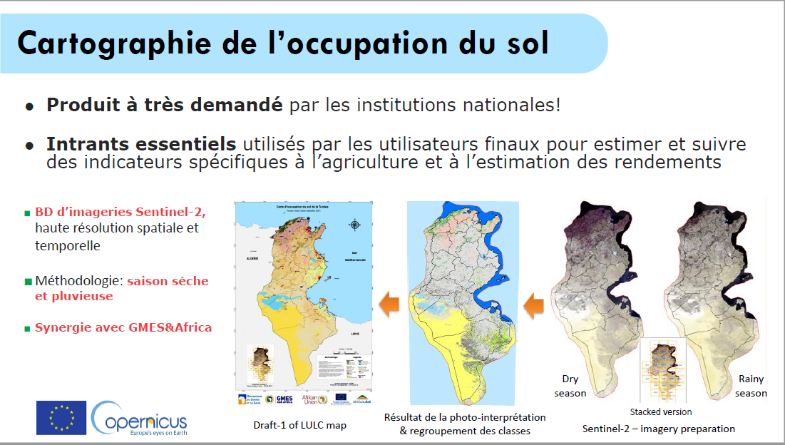
Crop type and land use maps
Crop type maps and land use maps were developed for the study areas in Tunisia, and also at the national level (plus a technical note).
Example of a crop type map:
For bigger maps contact louis.zoungrana@oss.org.tn
For more examples of the study area maps, a map at national level plus a technical note click on more...
Support to Irrigation in Tunisia
 Click on the picture to download the PowerPoint presentation.
Presentation Evence Zoungrana
At the follow-up webinar in French that was held on May 31 2022, l’Afrique et les donnes spatiales Europeénnes, Evence Zoungrana gave a presentation on the use of Copernicus data for agricultural monitoring in Tunisia.
Click on the picture below to see the presentation.
AfriCultuReS Tunisia use cases presentation in French
AfriCultuReS Tunisia services demo
AfriCultuReS Tunisia platform demo
Workshop OSS 2021
The 4th AfriCultuReS workshop of OSS was held on December 15 and 15, 2021 with the aim to present the AfriCultuReS services and products and the results of the project in Tunisia. The videos of the services, the platform demonstration and the uses cases in Tunisia can be found on this webpage.
Concept note of the event (English)
Concept note of the event (French)
For the links to the presentations click on more...
Scientific publication and technical report
A scientific publication was dedicated to the activities in Tunisia: “Supervised Machine learning for Crop mapping using Sentinel-2 time-series imageries - Case studies in Jendouba and Tunisia” (https://doi.org/10.4018/978-1-7998-1954-7.ch008). You also can find it here.
A report on the establishment of the national geoportal for Tunisia was published in June 2021. It is called “Développement d’une plateforme géospatiale dédiée à la diffusion des données cartographiques (Tunisie)” and available here.
Workshop OSS December 15 and 16 2020
National and regional governments are interested in creating the conditions for increasing agricultural production and productivity and reducing risk. Earth observation is an excellent tool to support informed decision-making. With this in mind the Sahara and Sahel Observatory (OSS) held a national workshop for presenting the results of the AfriCultuReS project in Tunisia on December 15 and 16 2020.
Click for the announcement of the workshop (in French)
Click for the leaflet (in French)
For the links to all presentations click on more...
Tele-training by OSS
OSS organised a “Tele-training on operational modelling of wheat growth and its yield estimate” within the framework of the AfriCultuReS and GMES-Africa projects in partnership with the CNCT (National Center for Mapping and Remote Sensing) - ONAGRI (National Observatory of Agriculture) and INRGREF (National Institute for Research in Rural Engineering, Water and Forests), from 20 to 22 April 2020.
Concept note (English)
Concept note (French)
Report on the methodology
If you are interested in doing the training yourself, please contact Evence Zoungrana at louis.zoungrana@oss.org.tn
For the links to presentations on monitoring campaigns in Tunisia and presentations of the AfriCultuReS consortium click on more...
Workshop OSS October 29 and 30 2019
On October 29 and 30 a workshop was held on feedback of the thematic studies and the assessment of the end user needs for the application of Earth observation for food security.
Click for the concept note
For the links to all presentations click on more...


